You are here: Home > Network List > AV - Alaska Volcano Observatory Stations List
> Station AMKA Regional Station, Amchitka Island, Alaska > Earthquake Result Viewer
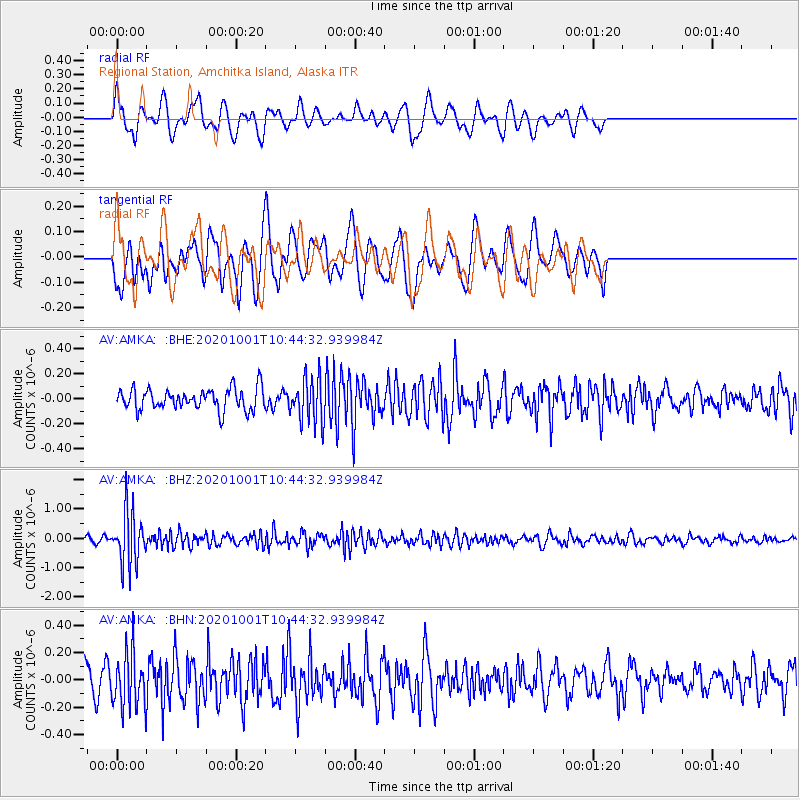
AMKA Regional Station, Amchitka Island, Alaska - Earthquake Result Viewer
*The percent match for this event was below the threshold and hence no stack was calculated.
| Earthquake location: |
New Britain Region, P.N.G. |
| Earthquake latitude/longitude: |
-6.1/148.7 |
| Earthquake time(UTC): |
2020/10/01 (275) 10:34:48 GMT |
| Earthquake Depth: |
109 km |
| Earthquake Magnitude: |
6.0 mww |
| Earthquake Catalog/Contributor: |
NEIC PDE/us |
|
| Network: |
AV Alaska Volcano Observatory |
| Station: |
AMKA Regional Station, Amchitka Island, Alaska |
| Lat/Lon: |
51.38 N/179.30 E |
| Elevation: |
116 m |
|
| Distance: |
63.0 deg |
| Az: |
21.012 deg |
| Baz: |
214.675 deg |
| Ray Param: |
$rayparam |
*The percent match for this event was below the threshold and hence was not used in the summary stack. |
|
| Radial Match: |
63.1009 % |
| Radial Bump: |
400 |
| Transverse Match: |
56.12005 % |
| Transverse Bump: |
400 |
| SOD ConfigId: |
22732711 |
| Insert Time: |
2020-10-15 10:39:12.438 +0000 |
| GWidth: |
2.5 |
| Max Bumps: |
400 |
| Tol: |
0.001 |
|
Signal To Noise
| Channel | StoN | STA | LTA |
| AV:AMKA: :BHZ:20201001T10:44:32.939984Z | 8.651261 | 8.9884884E-7 | 1.0389802E-7 |
| AV:AMKA: :BHN:20201001T10:44:32.939984Z | 2.2793536 | 1.99017E-7 | 8.731291E-8 |
| AV:AMKA: :BHE:20201001T10:44:32.939984Z | 2.0941293 | 1.7759683E-7 | 8.4807E-8 |
| Arrivals |
| Ps | |
| PpPs | |
| PsPs/PpSs | |


