You are here: Home > Network List > XT97 - Colorado BB Array - Lodore Stations List
> Station LIME XT.LIME > Earthquake Result Viewer
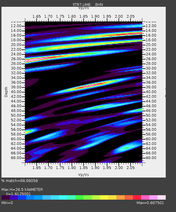
LIME XT.LIME - Earthquake Result Viewer
| Earthquake location: |
Fiji Islands Region |
| Earthquake latitude/longitude: |
-17.6/-179.1 |
| Earthquake time(UTC): |
1998/03/29 (088) 19:48:16 GMT |
| Earthquake Depth: |
537 km |
| Earthquake Magnitude: |
6.5 MB, 7.2 UNKNOWN, 7.1 MW |
| Earthquake Catalog/Contributor: |
WHDF/NEIC |
|
| Network: |
XT Colorado BB Array - Lodore |
| Station: |
LIME XT.LIME |
| Lat/Lon: |
40.87 N/108.79 W |
| Elevation: |
2371 m |
|
| Distance: |
87.2 deg |
| Az: |
45.629 deg |
| Baz: |
244.063 deg |
| Ray Param: |
0.04198121 |
| Estimated Moho Depth: |
26.5 km |
| Estimated Crust Vp/Vs: |
1.61 |
| Assumed Crust Vp: |
6.207 km/s |
| Estimated Crust Vs: |
3.849 km/s |
| Estimated Crust Poisson's Ratio: |
0.19 |
|
| Radial Match: |
86.86056 % |
| Radial Bump: |
400 |
| Transverse Match: |
85.11793 % |
| Transverse Bump: |
400 |
| SOD ConfigId: |
4480 |
| Insert Time: |
2010-03-09 01:38:22.959 +0000 |
| GWidth: |
2.5 |
| Max Bumps: |
400 |
| Tol: |
0.001 |
|

Signal To Noise
| Channel | StoN | STA | LTA |
| XT:LIME: :BHN:19980329T19:59:34.249011Z | 70.76649 | 1.32566265E-5 | 1.8732916E-7 |
| XT:LIME: :BHE:19980329T19:59:34.249011Z | 2.7032466 | 7.553925E-7 | 2.7943898E-7 |
| XT:LIME: :BHZ:19980329T19:59:34.249011Z | 6.955651 | 3.1370448E-6 | 4.5100663E-7 |
| Arrivals |
| Ps | 2.7 SECOND |
| PpPs | 11 SECOND |
| PsPs/PpSs | 14 SECOND |


