You are here: Home > Network List > TA - USArray Transportable Network (new EarthScope stations) Stations List
> Station POKR Poker Plat Research Range, AK, USA > Earthquake Result Viewer
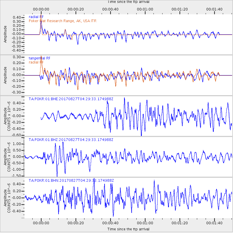
POKR Poker Plat Research Range, AK, USA - Earthquake Result Viewer
*The percent match for this event was below the threshold and hence no stack was calculated.
| Earthquake location: |
Admiralty Islands Region, P.N.G. |
| Earthquake latitude/longitude: |
-1.4/148.1 |
| Earthquake time(UTC): |
2017/08/27 (239) 04:17:51 GMT |
| Earthquake Depth: |
10 km |
| Earthquake Magnitude: |
6.6 Mi |
| Earthquake Catalog/Contributor: |
NEIC PDE/at |
|
| Network: |
TA USArray Transportable Network (new EarthScope stations) |
| Station: |
POKR Poker Plat Research Range, AK, USA |
| Lat/Lon: |
65.12 N/147.43 W |
| Elevation: |
501 m |
|
| Distance: |
80.8 deg |
| Az: |
22.754 deg |
| Baz: |
246.049 deg |
| Ray Param: |
$rayparam |
*The percent match for this event was below the threshold and hence was not used in the summary stack. |
|
| Radial Match: |
67.30176 % |
| Radial Bump: |
400 |
| Transverse Match: |
74.12355 % |
| Transverse Bump: |
400 |
| SOD ConfigId: |
2140511 |
| Insert Time: |
2017-09-09 20:14:51.232 +0000 |
| GWidth: |
2.5 |
| Max Bumps: |
400 |
| Tol: |
0.001 |
|
Signal To Noise
| Channel | StoN | STA | LTA |
| TA:POKR:01:BHZ:20170827T04:29:33.174988Z | 1.9730613 | 1.8872701E-7 | 9.565187E-8 |
| TA:POKR:01:BHN:20170827T04:29:33.174988Z | 1.1798908 | 8.1489816E-8 | 6.9065564E-8 |
| TA:POKR:01:BHE:20170827T04:29:33.174988Z | 1.6331555 | 1.0859658E-7 | 6.649494E-8 |
| Arrivals |
| Ps | |
| PpPs | |
| PsPs/PpSs | |


