You are here: Home > Network List > AV - Alaska Volcano Observatory Stations List
> Station AMKA Regional Station, Amchitka Island, Alaska > Earthquake Result Viewer
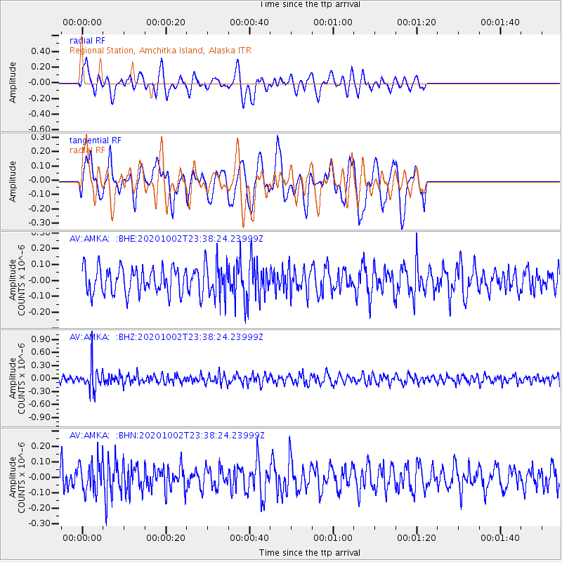
AMKA Regional Station, Amchitka Island, Alaska - Earthquake Result Viewer
*The percent match for this event was below the threshold and hence no stack was calculated.
| Earthquake location: |
Mariana Islands |
| Earthquake latitude/longitude: |
18.8/146.0 |
| Earthquake time(UTC): |
2020/10/02 (276) 23:31:13 GMT |
| Earthquake Depth: |
78 km |
| Earthquake Magnitude: |
5.2 Mww |
| Earthquake Catalog/Contributor: |
NEIC PDE/us |
|
| Network: |
AV Alaska Volcano Observatory |
| Station: |
AMKA Regional Station, Amchitka Island, Alaska |
| Lat/Lon: |
51.38 N/179.30 E |
| Elevation: |
116 m |
|
| Distance: |
41.8 deg |
| Az: |
31.143 deg |
| Baz: |
231.405 deg |
| Ray Param: |
$rayparam |
*The percent match for this event was below the threshold and hence was not used in the summary stack. |
|
| Radial Match: |
54.74343 % |
| Radial Bump: |
325 |
| Transverse Match: |
56.023968 % |
| Transverse Bump: |
400 |
| SOD ConfigId: |
22732711 |
| Insert Time: |
2020-10-16 23:34:43.555 +0000 |
| GWidth: |
2.5 |
| Max Bumps: |
400 |
| Tol: |
0.001 |
|
Signal To Noise
| Channel | StoN | STA | LTA |
| AV:AMKA: :BHZ:20201002T23:38:24.23999Z | 3.5852768 | 2.8087524E-7 | 7.83413E-8 |
| AV:AMKA: :BHN:20201002T23:38:24.23999Z | 1.4808491 | 9.785852E-8 | 6.6082706E-8 |
| AV:AMKA: :BHE:20201002T23:38:24.23999Z | 1.3687383 | 1.0700571E-7 | 7.817836E-8 |
| Arrivals |
| Ps | |
| PpPs | |
| PsPs/PpSs | |


