You are here: Home > Network List > AV - Alaska Volcano Observatory Stations List
> Station AMKA Regional Station, Amchitka Island, Alaska > Earthquake Result Viewer
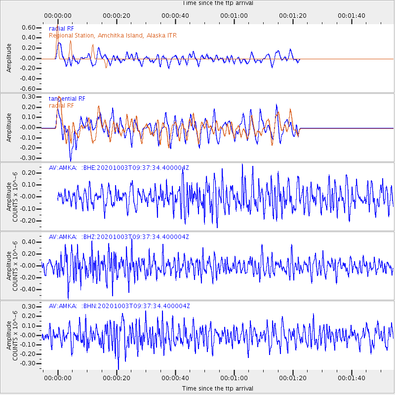
AMKA Regional Station, Amchitka Island, Alaska - Earthquake Result Viewer
*The percent match for this event was below the threshold and hence no stack was calculated.
| Earthquake location: |
Southeast Of Honshu, Japan |
| Earthquake latitude/longitude: |
33.5/140.9 |
| Earthquake time(UTC): |
2020/10/03 (277) 09:31:35 GMT |
| Earthquake Depth: |
59 km |
| Earthquake Magnitude: |
5.5 mww |
| Earthquake Catalog/Contributor: |
NEIC PDE/us |
|
| Network: |
AV Alaska Volcano Observatory |
| Station: |
AMKA Regional Station, Amchitka Island, Alaska |
| Lat/Lon: |
51.38 N/179.30 E |
| Elevation: |
116 m |
|
| Distance: |
33.0 deg |
| Az: |
45.619 deg |
| Baz: |
252.298 deg |
| Ray Param: |
$rayparam |
*The percent match for this event was below the threshold and hence was not used in the summary stack. |
|
| Radial Match: |
54.195812 % |
| Radial Bump: |
400 |
| Transverse Match: |
59.91746 % |
| Transverse Bump: |
400 |
| SOD ConfigId: |
22732711 |
| Insert Time: |
2020-10-17 09:36:30.790 +0000 |
| GWidth: |
2.5 |
| Max Bumps: |
400 |
| Tol: |
0.001 |
|
Signal To Noise
| Channel | StoN | STA | LTA |
| AV:AMKA: :BHZ:20201003T09:37:34.400004Z | 3.2072303 | 2.0464078E-7 | 6.380608E-8 |
| AV:AMKA: :BHN:20201003T09:37:34.400004Z | 1.1353124 | 7.314366E-8 | 6.442602E-8 |
| AV:AMKA: :BHE:20201003T09:37:34.400004Z | 0.91354066 | 5.3507375E-8 | 5.857142E-8 |
| Arrivals |
| Ps | |
| PpPs | |
| PsPs/PpSs | |


