You are here: Home > Network List > CI - Caltech Regional Seismic Network Stations List
> Station TIN Tinemaha, Big Pine, CA, USA > Earthquake Result Viewer
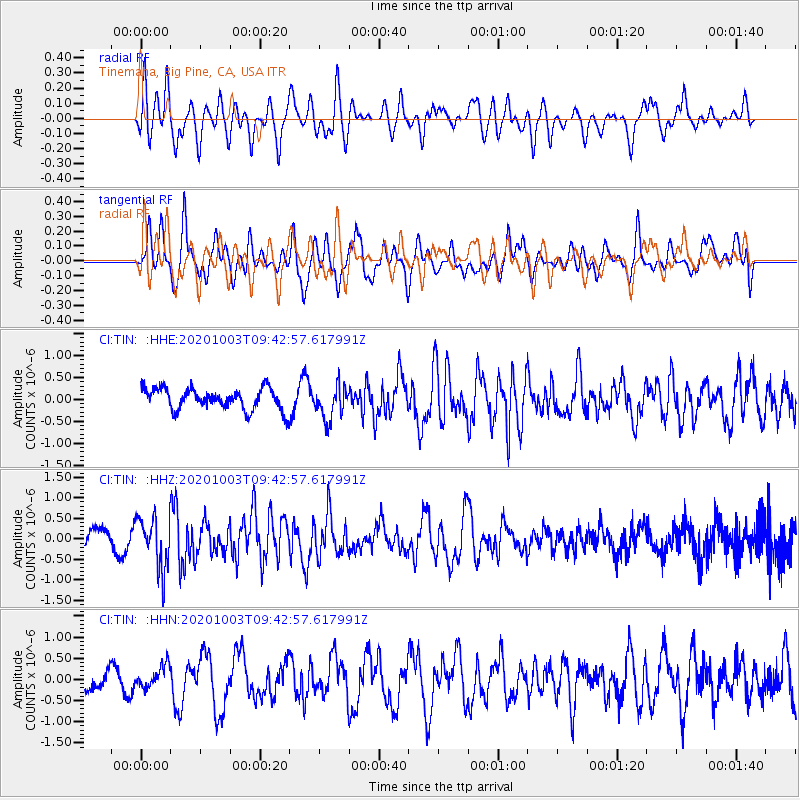
TIN Tinemaha, Big Pine, CA, USA - Earthquake Result Viewer
*The percent match for this event was below the threshold and hence no stack was calculated.
| Earthquake location: |
Southeast Of Honshu, Japan |
| Earthquake latitude/longitude: |
33.5/140.9 |
| Earthquake time(UTC): |
2020/10/03 (277) 09:31:35 GMT |
| Earthquake Depth: |
59 km |
| Earthquake Magnitude: |
5.5 mww |
| Earthquake Catalog/Contributor: |
NEIC PDE/us |
|
| Network: |
CI Caltech Regional Seismic Network |
| Station: |
TIN Tinemaha, Big Pine, CA, USA |
| Lat/Lon: |
37.05 N/118.23 W |
| Elevation: |
1197 m |
|
| Distance: |
78.2 deg |
| Az: |
53.367 deg |
| Baz: |
303.074 deg |
| Ray Param: |
$rayparam |
*The percent match for this event was below the threshold and hence was not used in the summary stack. |
|
| Radial Match: |
57.554947 % |
| Radial Bump: |
400 |
| Transverse Match: |
68.18816 % |
| Transverse Bump: |
400 |
| SOD ConfigId: |
22732711 |
| Insert Time: |
2020-10-17 09:40:35.310 +0000 |
| GWidth: |
2.5 |
| Max Bumps: |
400 |
| Tol: |
0.001 |
|
Signal To Noise
| Channel | StoN | STA | LTA |
| CI:TIN: :HHZ:20201003T09:42:57.617991Z | 2.6813567 | 6.233303E-7 | 2.3246825E-7 |
| CI:TIN: :HHN:20201003T09:42:57.617991Z | 0.8858272 | 2.589042E-7 | 2.9227397E-7 |
| CI:TIN: :HHE:20201003T09:42:57.617991Z | 1.5468752 | 3.7866118E-7 | 2.4479104E-7 |
| Arrivals |
| Ps | |
| PpPs | |
| PsPs/PpSs | |


