You are here: Home > Network List > TA - USArray Transportable Network (new EarthScope stations) Stations List
> Station G16K Koyuk River, AK, USA > Earthquake Result Viewer
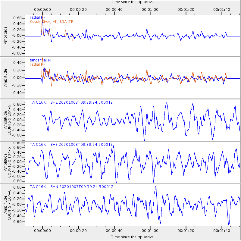
G16K Koyuk River, AK, USA - Earthquake Result Viewer
*The percent match for this event was below the threshold and hence no stack was calculated.
| Earthquake location: |
Southeast Of Honshu, Japan |
| Earthquake latitude/longitude: |
33.5/140.9 |
| Earthquake time(UTC): |
2020/10/03 (277) 09:31:35 GMT |
| Earthquake Depth: |
59 km |
| Earthquake Magnitude: |
5.5 mww |
| Earthquake Catalog/Contributor: |
NEIC PDE/us |
|
| Network: |
TA USArray Transportable Network (new EarthScope stations) |
| Station: |
G16K Koyuk River, AK, USA |
| Lat/Lon: |
65.39 N/162.35 W |
| Elevation: |
169 m |
|
| Distance: |
46.3 deg |
| Az: |
28.97 deg |
| Baz: |
255.103 deg |
| Ray Param: |
$rayparam |
*The percent match for this event was below the threshold and hence was not used in the summary stack. |
|
| Radial Match: |
54.587093 % |
| Radial Bump: |
400 |
| Transverse Match: |
55.659184 % |
| Transverse Bump: |
400 |
| SOD ConfigId: |
22732711 |
| Insert Time: |
2020-10-17 09:51:42.087 +0000 |
| GWidth: |
2.5 |
| Max Bumps: |
400 |
| Tol: |
0.001 |
|
Signal To Noise
| Channel | StoN | STA | LTA |
| TA:G16K: :BHZ:20201003T09:39:24.50001Z | 1.8363206 | 4.4204776E-7 | 2.4072472E-7 |
| TA:G16K: :BHN:20201003T09:39:24.50001Z | 0.8719556 | 1.8924474E-7 | 2.1703485E-7 |
| TA:G16K: :BHE:20201003T09:39:24.50001Z | 0.9754325 | 1.8103886E-7 | 1.8559855E-7 |
| Arrivals |
| Ps | |
| PpPs | |
| PsPs/PpSs | |


