You are here: Home > Network List > GO - National Seismic Network of Georgia Stations List
> Station TBLG Delisi, Georgia > Earthquake Result Viewer
TBLG Delisi, Georgia - Earthquake Result Viewer
| Earthquake location: |
Eastern Greenland |
| Earthquake latitude/longitude: |
69.3/-29.8 |
| Earthquake time(UTC): |
2020/10/03 (277) 13:22:47 GMT |
| Earthquake Depth: |
10 km |
| Earthquake Magnitude: |
5.3 Mww |
| Earthquake Catalog/Contributor: |
NEIC PDE/us |
|
| Network: |
GO National Seismic Network of Georgia |
| Station: |
TBLG Delisi, Georgia |
| Lat/Lon: |
41.73 N/44.74 E |
| Elevation: |
510 m |
|
| Distance: |
46.3 deg |
| Az: |
86.12 deg |
| Baz: |
331.713 deg |
| Ray Param: |
0.07074518 |
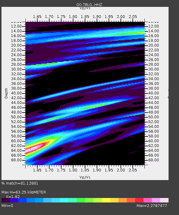
| Estimated Moho Depth: |
63.25 km |
| Estimated Crust Vp/Vs: |
1.62 |
| Assumed Crust Vp: |
6.291 km/s |
| Estimated Crust Vs: |
3.883 km/s |
| Estimated Crust Poisson's Ratio: |
0.19 |
|
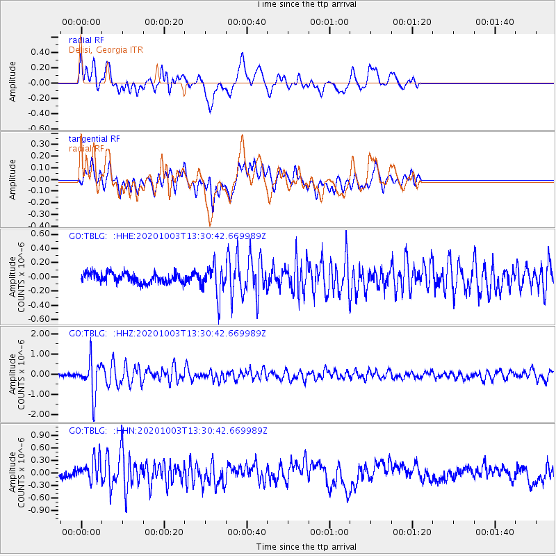
| Radial Match: |
81.12681 % |
| Radial Bump: |
400 |
| Transverse Match: |
74.01417 % |
| Transverse Bump: |
400 |
| SOD ConfigId: |
22732711 |
| Insert Time: |
2020-10-17 13:32:53.799 +0000 |
| GWidth: |
2.5 |
| Max Bumps: |
400 |
| Tol: |
0.001 |
|
Signal To Noise
| Channel | StoN | STA | LTA |
| GO:TBLG: :HHZ:20201003T13:30:42.669989Z | 13.634174 | 8.8833264E-7 | 6.515485E-8 |
| GO:TBLG: :HHN:20201003T13:30:42.669989Z | 2.055956 | 2.6422228E-7 | 1.2851554E-7 |
| GO:TBLG: :HHE:20201003T13:30:42.669989Z | 3.1501286 | 2.1521625E-7 | 6.831983E-8 |
| Arrivals |
| Ps | 6.7 SECOND |
| PpPs | 25 SECOND |
| PsPs/PpSs | 31 SECOND |


