You are here: Home > Network List > IU - Global Seismograph Network (GSN - IRIS/USGS) Stations List
> Station CTAO Charters Towers, Australia > Earthquake Result Viewer
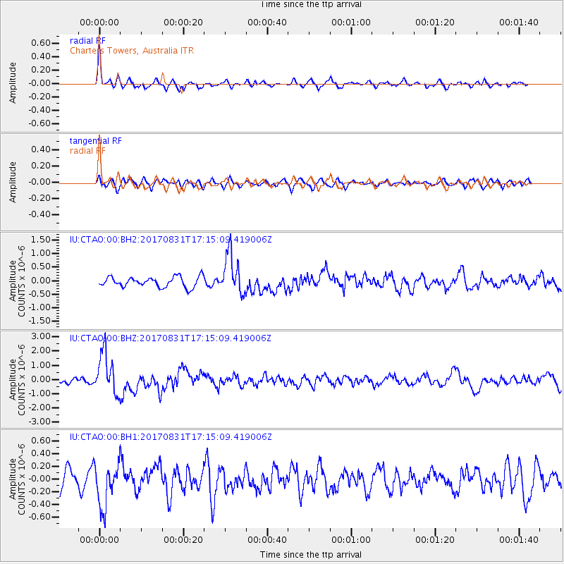
CTAO Charters Towers, Australia - Earthquake Result Viewer
*The percent match for this event was below the threshold and hence no stack was calculated.
| Earthquake location: |
Southern Sumatra, Indonesia |
| Earthquake latitude/longitude: |
-1.2/99.7 |
| Earthquake time(UTC): |
2017/08/31 (243) 17:06:55 GMT |
| Earthquake Depth: |
43 km |
| Earthquake Magnitude: |
6.3 Mww |
| Earthquake Catalog/Contributor: |
NEIC PDE/us |
|
| Network: |
IU Global Seismograph Network (GSN - IRIS/USGS) |
| Station: |
CTAO Charters Towers, Australia |
| Lat/Lon: |
20.09 S/146.25 E |
| Elevation: |
357 m |
|
| Distance: |
49.2 deg |
| Az: |
115.693 deg |
| Baz: |
286.555 deg |
| Ray Param: |
$rayparam |
*The percent match for this event was below the threshold and hence was not used in the summary stack. |
|
| Radial Match: |
74.15593 % |
| Radial Bump: |
400 |
| Transverse Match: |
52.356792 % |
| Transverse Bump: |
400 |
| SOD ConfigId: |
2307692 |
| Insert Time: |
2017-09-14 17:48:09.952 +0000 |
| GWidth: |
2.5 |
| Max Bumps: |
400 |
| Tol: |
0.001 |
|
Signal To Noise
| Channel | StoN | STA | LTA |
| IU:CTAO:00:BHZ:20170831T17:15:09.419006Z | 8.961319 | 1.4956858E-6 | 1.6690464E-7 |
| IU:CTAO:00:BH1:20170831T17:15:09.419006Z | 2.4406095 | 3.4456437E-7 | 1.4117964E-7 |
| IU:CTAO:00:BH2:20170831T17:15:09.419006Z | 4.014562 | 7.55592E-7 | 1.8821282E-7 |
| Arrivals |
| Ps | |
| PpPs | |
| PsPs/PpSs | |


