You are here: Home > Network List > TA - USArray Transportable Network (new EarthScope stations) Stations List
> Station G21K Allakaket, AK, USA > Earthquake Result Viewer
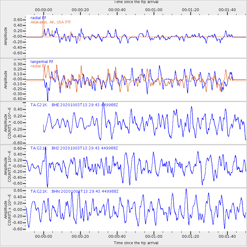
G21K Allakaket, AK, USA - Earthquake Result Viewer
*The percent match for this event was below the threshold and hence no stack was calculated.
| Earthquake location: |
Eastern Greenland |
| Earthquake latitude/longitude: |
69.3/-29.8 |
| Earthquake time(UTC): |
2020/10/03 (277) 13:22:47 GMT |
| Earthquake Depth: |
10 km |
| Earthquake Magnitude: |
5.3 Mww |
| Earthquake Catalog/Contributor: |
NEIC PDE/us |
|
| Network: |
TA USArray Transportable Network (new EarthScope stations) |
| Station: |
G21K Allakaket, AK, USA |
| Lat/Lon: |
66.52 N/153.51 W |
| Elevation: |
446 m |
|
| Distance: |
39.0 deg |
| Az: |
328.019 deg |
| Baz: |
28.025 deg |
| Ray Param: |
$rayparam |
*The percent match for this event was below the threshold and hence was not used in the summary stack. |
|
| Radial Match: |
49.979053 % |
| Radial Bump: |
400 |
| Transverse Match: |
62.142735 % |
| Transverse Bump: |
400 |
| SOD ConfigId: |
22732711 |
| Insert Time: |
2020-10-17 13:44:21.268 +0000 |
| GWidth: |
2.5 |
| Max Bumps: |
400 |
| Tol: |
0.001 |
|
Signal To Noise
| Channel | StoN | STA | LTA |
| TA:G21K: :BHZ:20201003T13:29:43.449988Z | 2.6285803 | 3.1840756E-7 | 1.211329E-7 |
| TA:G21K: :BHN:20201003T13:29:43.449988Z | 0.9156833 | 2.1413362E-7 | 2.3385117E-7 |
| TA:G21K: :BHE:20201003T13:29:43.449988Z | 2.4188077 | 3.4555617E-7 | 1.4286219E-7 |
| Arrivals |
| Ps | |
| PpPs | |
| PsPs/PpSs | |


