You are here: Home > Network List > US - United States National Seismic Network Stations List
> Station LAO LASA Array, Montana, USA > Earthquake Result Viewer
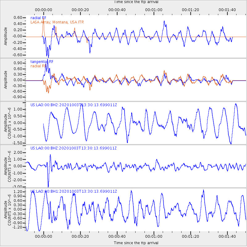
LAO LASA Array, Montana, USA - Earthquake Result Viewer
*The percent match for this event was below the threshold and hence no stack was calculated.
| Earthquake location: |
Eastern Greenland |
| Earthquake latitude/longitude: |
69.3/-29.8 |
| Earthquake time(UTC): |
2020/10/03 (277) 13:22:47 GMT |
| Earthquake Depth: |
10 km |
| Earthquake Magnitude: |
5.3 Mww |
| Earthquake Catalog/Contributor: |
NEIC PDE/us |
|
| Network: |
US United States National Seismic Network |
| Station: |
LAO LASA Array, Montana, USA |
| Lat/Lon: |
46.69 N/106.22 W |
| Elevation: |
902 m |
|
| Distance: |
42.7 deg |
| Az: |
279.095 deg |
| Baz: |
30.661 deg |
| Ray Param: |
$rayparam |
*The percent match for this event was below the threshold and hence was not used in the summary stack. |
|
| Radial Match: |
80.84704 % |
| Radial Bump: |
395 |
| Transverse Match: |
78.57707 % |
| Transverse Bump: |
376 |
| SOD ConfigId: |
22732711 |
| Insert Time: |
2020-10-17 13:47:41.405 +0000 |
| GWidth: |
2.5 |
| Max Bumps: |
400 |
| Tol: |
0.001 |
|
Signal To Noise
| Channel | StoN | STA | LTA |
| US:LAO:00:BHZ:20201003T13:30:13.699011Z | 2.4936004 | 1.0195312E-6 | 4.0885908E-7 |
| US:LAO:00:BH1:20201003T13:30:13.699011Z | 1.099803 | 7.172623E-7 | 6.521734E-7 |
| US:LAO:00:BH2:20201003T13:30:13.699011Z | 0.40259802 | 3.1214068E-7 | 7.7531604E-7 |
| Arrivals |
| Ps | |
| PpPs | |
| PsPs/PpSs | |


