You are here: Home > Network List > UU - University of Utah Regional Network Stations List
> Station CCUT Cedar City, UT, USA > Earthquake Result Viewer
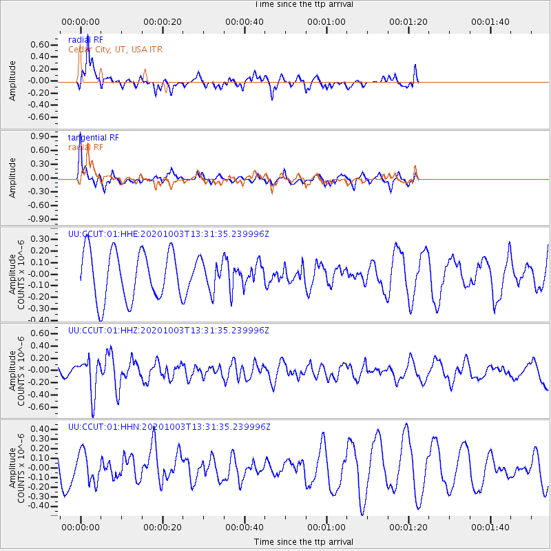
CCUT Cedar City, UT, USA - Earthquake Result Viewer
*The percent match for this event was below the threshold and hence no stack was calculated.
| Earthquake location: |
Eastern Greenland |
| Earthquake latitude/longitude: |
69.3/-29.8 |
| Earthquake time(UTC): |
2020/10/03 (277) 13:22:47 GMT |
| Earthquake Depth: |
10 km |
| Earthquake Magnitude: |
5.3 Mww |
| Earthquake Catalog/Contributor: |
NEIC PDE/us |
|
| Network: |
UU University of Utah Regional Network |
| Station: |
CCUT Cedar City, UT, USA |
| Lat/Lon: |
37.55 N/113.36 W |
| Elevation: |
2127 m |
|
| Distance: |
53.2 deg |
| Az: |
279.547 deg |
| Baz: |
26.175 deg |
| Ray Param: |
$rayparam |
*The percent match for this event was below the threshold and hence was not used in the summary stack. |
|
| Radial Match: |
49.26497 % |
| Radial Bump: |
364 |
| Transverse Match: |
62.86481 % |
| Transverse Bump: |
400 |
| SOD ConfigId: |
22732711 |
| Insert Time: |
2020-10-17 13:48:08.609 +0000 |
| GWidth: |
2.5 |
| Max Bumps: |
400 |
| Tol: |
0.001 |
|
Signal To Noise
| Channel | StoN | STA | LTA |
| UU:CCUT:01:HHZ:20201003T13:31:35.239996Z | 1.9442097 | 2.9474467E-7 | 1.5160127E-7 |
| UU:CCUT:01:HHN:20201003T13:31:35.239996Z | 0.60822403 | 1.5829225E-7 | 2.6025322E-7 |
| UU:CCUT:01:HHE:20201003T13:31:35.239996Z | 0.60090524 | 1.2645116E-7 | 2.1043444E-7 |
| Arrivals |
| Ps | |
| PpPs | |
| PsPs/PpSs | |


