You are here: Home > Network List > UW - Pacific Northwest Regional Seismic Network Stations List
> Station LEBA Lebam, WA, USA > Earthquake Result Viewer
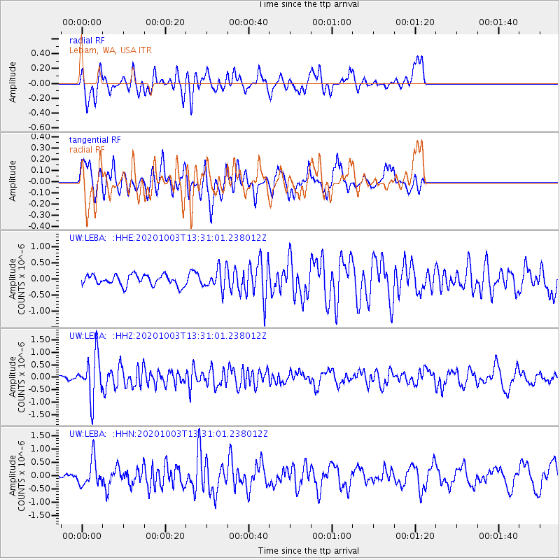
LEBA Lebam, WA, USA - Earthquake Result Viewer
*The percent match for this event was below the threshold and hence no stack was calculated.
| Earthquake location: |
Eastern Greenland |
| Earthquake latitude/longitude: |
69.3/-29.8 |
| Earthquake time(UTC): |
2020/10/03 (277) 13:22:47 GMT |
| Earthquake Depth: |
10 km |
| Earthquake Magnitude: |
5.3 Mww |
| Earthquake Catalog/Contributor: |
NEIC PDE/us |
|
| Network: |
UW Pacific Northwest Regional Seismic Network |
| Station: |
LEBA Lebam, WA, USA |
| Lat/Lon: |
46.55 N/123.56 W |
| Elevation: |
73 m |
|
| Distance: |
48.7 deg |
| Az: |
293.533 deg |
| Baz: |
28.181 deg |
| Ray Param: |
$rayparam |
*The percent match for this event was below the threshold and hence was not used in the summary stack. |
|
| Radial Match: |
58.134567 % |
| Radial Bump: |
400 |
| Transverse Match: |
56.81602 % |
| Transverse Bump: |
400 |
| SOD ConfigId: |
22732711 |
| Insert Time: |
2020-10-17 13:49:00.089 +0000 |
| GWidth: |
2.5 |
| Max Bumps: |
400 |
| Tol: |
0.001 |
|
Signal To Noise
| Channel | StoN | STA | LTA |
| UW:LEBA: :HHZ:20201003T13:31:01.238012Z | 3.5338168 | 8.6815066E-7 | 2.456694E-7 |
| UW:LEBA: :HHN:20201003T13:31:01.238012Z | 2.486015 | 5.107137E-7 | 2.0543469E-7 |
| UW:LEBA: :HHE:20201003T13:31:01.238012Z | 2.0044382 | 3.271328E-7 | 1.6320423E-7 |
| Arrivals |
| Ps | |
| PpPs | |
| PsPs/PpSs | |


