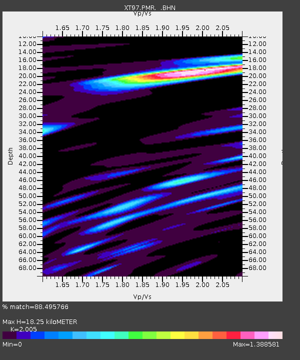
PMR XT.PMR - Earthquake Result Viewer

Earthquake location: Off East Coast Of Kamchatka
Earthquake latitude/longitude: 52.9/160.1
Earthquake time(UTC): 1998/06/01 (152) 05:34:03 GMT
Earthquake Depth: 44 km
Earthquake Magnitude: 6.2 MB, 6.3 MS, 6.5 UNKNOWN, 6.4 MW
Earthquake Catalog/Contributor: WHDF/NEIC
Network: XT Colorado BB Array - Lodore
Station: PMR XT.PMR
Lat/Lon: 41.08 N/108.82 W
Elevation: 2164 m
Distance: 59.2 deg
Az: 61.617 deg
Baz: 315.152 deg
Ray Param: 0.06224508
Estimated Moho Depth: 18.25 km
Estimated Crust Vp/Vs: 2.01
Assumed Crust Vp: 6.207 km/s
Estimated Crust Vs: 3.096 km/s
Estimated Crust Poisson's Ratio: 0.33
Radial Match: 88.495766 %
Radial Bump: 400
Transverse Match: 79.13705 %
Transverse Bump: 400
SOD ConfigId: 4480
Insert Time: 2010-03-09 01:42:16.841 +0000
GWidth: 2.5
Max Bumps: 400
Tol: 0.001

Signal To Noise

ChannelStoNSTALTA
XT:PMR: :BHN:19980601T05:43:29.473999Z16.3605981.5978345E-69.766357E-8
XT:PMR: :BHE:19980601T05:43:29.473999Z3.88354684.996957E-71.2866994E-7
XT:PMR: :BHZ:19980601T05:43:29.473999Z2.0366044.0872482E-72.0068939E-7
Arrivals
Ps3.1 SECOND
PpPs8.5 SECOND
PsPs/PpSs12 SECOND