You are here: Home > Network List > CU - Caribbean Network (USGS) Stations List
> Station BBGH Gun Hill, Barbados > Earthquake Result Viewer
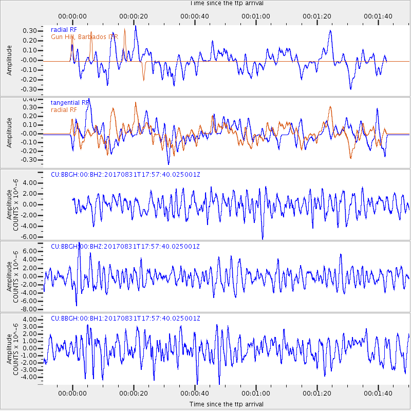
BBGH Gun Hill, Barbados - Earthquake Result Viewer
*The percent match for this event was below the threshold and hence no stack was calculated.
| Earthquake location: |
Kodiak Island Region, Alaska |
| Earthquake latitude/longitude: |
58.5/-153.7 |
| Earthquake time(UTC): |
2017/08/31 (243) 17:46:02 GMT |
| Earthquake Depth: |
62 km |
| Earthquake Magnitude: |
5.5 ml |
| Earthquake Catalog/Contributor: |
NEIC PDE/ak |
|
| Network: |
CU Caribbean Network (USGS) |
| Station: |
BBGH Gun Hill, Barbados |
| Lat/Lon: |
13.14 N/59.56 W |
| Elevation: |
180 m |
|
| Distance: |
81.0 deg |
| Az: |
79.624 deg |
| Baz: |
327.933 deg |
| Ray Param: |
$rayparam |
*The percent match for this event was below the threshold and hence was not used in the summary stack. |
|
| Radial Match: |
58.755577 % |
| Radial Bump: |
400 |
| Transverse Match: |
67.521706 % |
| Transverse Bump: |
400 |
| SOD ConfigId: |
2307692 |
| Insert Time: |
2017-09-14 17:50:10.484 +0000 |
| GWidth: |
2.5 |
| Max Bumps: |
400 |
| Tol: |
0.001 |
|
Signal To Noise
| Channel | StoN | STA | LTA |
| CU:BBGH:00:BHZ:20170831T17:57:40.025001Z | 2.8096194 | 3.5425185E-6 | 1.2608534E-6 |
| CU:BBGH:00:BH1:20170831T17:57:40.025001Z | 1.0601579 | 1.538818E-6 | 1.4514989E-6 |
| CU:BBGH:00:BH2:20170831T17:57:40.025001Z | 1.2995396 | 1.6643606E-6 | 1.280731E-6 |
| Arrivals |
| Ps | |
| PpPs | |
| PsPs/PpSs | |


