You are here: Home > Network List > G - GEOSCOPE Stations List
> Station CLF Chambon la Foret observatory, France > Earthquake Result Viewer
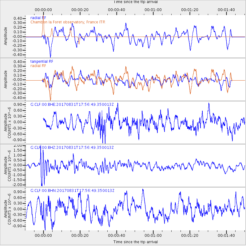
CLF Chambon la Foret observatory, France - Earthquake Result Viewer
*The percent match for this event was below the threshold and hence no stack was calculated.
| Earthquake location: |
Kodiak Island Region, Alaska |
| Earthquake latitude/longitude: |
58.5/-153.7 |
| Earthquake time(UTC): |
2017/08/31 (243) 17:46:02 GMT |
| Earthquake Depth: |
62 km |
| Earthquake Magnitude: |
5.5 ml |
| Earthquake Catalog/Contributor: |
NEIC PDE/ak |
|
| Network: |
G GEOSCOPE |
| Station: |
CLF Chambon la Foret observatory, France |
| Lat/Lon: |
48.03 N/2.26 E |
| Elevation: |
145 m |
|
| Distance: |
72.0 deg |
| Az: |
16.739 deg |
| Baz: |
346.962 deg |
| Ray Param: |
$rayparam |
*The percent match for this event was below the threshold and hence was not used in the summary stack. |
|
| Radial Match: |
53.500313 % |
| Radial Bump: |
400 |
| Transverse Match: |
51.47505 % |
| Transverse Bump: |
400 |
| SOD ConfigId: |
2307692 |
| Insert Time: |
2017-09-14 17:50:43.315 +0000 |
| GWidth: |
2.5 |
| Max Bumps: |
400 |
| Tol: |
0.001 |
|
Signal To Noise
| Channel | StoN | STA | LTA |
| G:CLF:00:BHZ:20170831T17:56:49.350013Z | 4.8339844 | 8.952422E-7 | 1.8519758E-7 |
| G:CLF:00:BHN:20170831T17:56:49.350013Z | 1.1797447 | 5.1855665E-7 | 4.3954986E-7 |
| G:CLF:00:BHE:20170831T17:56:49.350013Z | 1.795742 | 4.372008E-7 | 2.4346525E-7 |
| Arrivals |
| Ps | |
| PpPs | |
| PsPs/PpSs | |


