You are here: Home > Network List > GS - US Geological Survey Networks Stations List
> Station KAN09 East Station, Caldwell, KS, USA > Earthquake Result Viewer
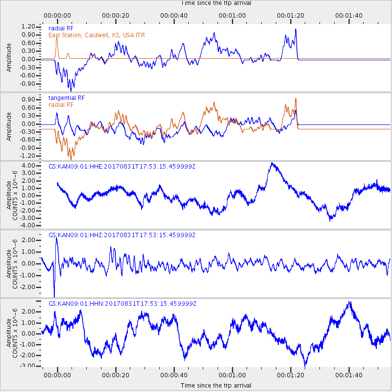
KAN09 East Station, Caldwell, KS, USA - Earthquake Result Viewer
*The percent match for this event was below the threshold and hence no stack was calculated.
| Earthquake location: |
Kodiak Island Region, Alaska |
| Earthquake latitude/longitude: |
58.5/-153.7 |
| Earthquake time(UTC): |
2017/08/31 (243) 17:46:02 GMT |
| Earthquake Depth: |
62 km |
| Earthquake Magnitude: |
5.5 ml |
| Earthquake Catalog/Contributor: |
NEIC PDE/ak |
|
| Network: |
GS US Geological Survey Networks |
| Station: |
KAN09 East Station, Caldwell, KS, USA |
| Lat/Lon: |
37.14 N/97.62 W |
| Elevation: |
371 m |
|
| Distance: |
41.7 deg |
| Az: |
95.494 deg |
| Baz: |
319.087 deg |
| Ray Param: |
$rayparam |
*The percent match for this event was below the threshold and hence was not used in the summary stack. |
|
| Radial Match: |
50.56212 % |
| Radial Bump: |
400 |
| Transverse Match: |
29.493294 % |
| Transverse Bump: |
400 |
| SOD ConfigId: |
2307692 |
| Insert Time: |
2017-09-14 17:51:20.821 +0000 |
| GWidth: |
2.5 |
| Max Bumps: |
400 |
| Tol: |
0.001 |
|
Signal To Noise
| Channel | StoN | STA | LTA |
| GS:KAN09:01:HHZ:20170831T17:53:15.459999Z | 3.3986335 | 9.596747E-7 | 2.8237076E-7 |
| GS:KAN09:01:HHN:20170831T17:53:15.459999Z | 3.072719 | 1.361175E-6 | 4.429871E-7 |
| GS:KAN09:01:HHE:20170831T17:53:15.459999Z | 1.0196619 | 7.2292744E-7 | 7.089874E-7 |
| Arrivals |
| Ps | |
| PpPs | |
| PsPs/PpSs | |


