You are here: Home > Network List > TA - USArray Transportable Network (new EarthScope stations) Stations List
> Station L15K Ungalak Mountain, AK, USA > Earthquake Result Viewer
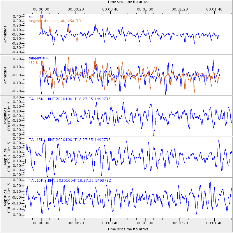
L15K Ungalak Mountain, AK, USA - Earthquake Result Viewer
*The percent match for this event was below the threshold and hence no stack was calculated.
| Earthquake location: |
Mindoro, Philippines |
| Earthquake latitude/longitude: |
13.6/120.7 |
| Earthquake time(UTC): |
2020/10/04 (278) 18:16:55 GMT |
| Earthquake Depth: |
137 km |
| Earthquake Magnitude: |
5.6 mww |
| Earthquake Catalog/Contributor: |
NEIC PDE/us |
|
| Network: |
TA USArray Transportable Network (new EarthScope stations) |
| Station: |
L15K Ungalak Mountain, AK, USA |
| Lat/Lon: |
61.68 N/161.49 W |
| Elevation: |
219 m |
|
| Distance: |
72.3 deg |
| Az: |
29.292 deg |
| Baz: |
265.831 deg |
| Ray Param: |
$rayparam |
*The percent match for this event was below the threshold and hence was not used in the summary stack. |
|
| Radial Match: |
55.728027 % |
| Radial Bump: |
400 |
| Transverse Match: |
54.130047 % |
| Transverse Bump: |
400 |
| SOD ConfigId: |
22732711 |
| Insert Time: |
2020-10-18 18:28:00.621 +0000 |
| GWidth: |
2.5 |
| Max Bumps: |
400 |
| Tol: |
0.001 |
|
Signal To Noise
| Channel | StoN | STA | LTA |
| TA:L15K: :BHZ:20201004T18:27:35.149973Z | 1.6392281 | 2.444076E-7 | 1.490992E-7 |
| TA:L15K: :BHN:20201004T18:27:35.149973Z | 1.2832186 | 1.6843809E-7 | 1.3126218E-7 |
| TA:L15K: :BHE:20201004T18:27:35.149973Z | 1.8832152 | 1.4357974E-7 | 7.624181E-8 |
| Arrivals |
| Ps | |
| PpPs | |
| PsPs/PpSs | |


