You are here: Home > Network List > AV - Alaska Volcano Observatory Stations List
> Station MAPS Pakushin Southeast, Makushin Volcano, Alaska > Earthquake Result Viewer
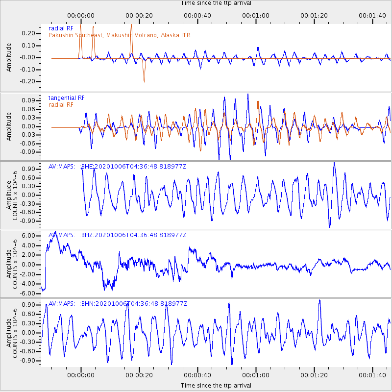
MAPS Pakushin Southeast, Makushin Volcano, Alaska - Earthquake Result Viewer
*The percent match for this event was below the threshold and hence no stack was calculated.
| Earthquake location: |
Northern Mid-Atlantic Ridge |
| Earthquake latitude/longitude: |
32.8/-39.8 |
| Earthquake time(UTC): |
2020/10/06 (280) 04:24:58 GMT |
| Earthquake Depth: |
10 km |
| Earthquake Magnitude: |
5.6 Mww |
| Earthquake Catalog/Contributor: |
NEIC PDE/us |
|
| Network: |
AV Alaska Volcano Observatory |
| Station: |
MAPS Pakushin Southeast, Makushin Volcano, Alaska |
| Lat/Lon: |
53.81 N/166.94 W |
| Elevation: |
333 m |
|
| Distance: |
82.3 deg |
| Az: |
331.489 deg |
| Baz: |
42.651 deg |
| Ray Param: |
$rayparam |
*The percent match for this event was below the threshold and hence was not used in the summary stack. |
|
| Radial Match: |
40.224155 % |
| Radial Bump: |
400 |
| Transverse Match: |
46.572605 % |
| Transverse Bump: |
400 |
| SOD ConfigId: |
22732711 |
| Insert Time: |
2020-10-20 04:28:27.299 +0000 |
| GWidth: |
2.5 |
| Max Bumps: |
400 |
| Tol: |
0.001 |
|
Signal To Noise
| Channel | StoN | STA | LTA |
| AV:MAPS: :BHZ:20201006T04:36:48.818977Z | 0.6424204 | 2.3161265E-6 | 3.6053125E-6 |
| AV:MAPS: :BHN:20201006T04:36:48.818977Z | 0.53440034 | 2.3699195E-7 | 4.4347266E-7 |
| AV:MAPS: :BHE:20201006T04:36:48.818977Z | 0.6145012 | 2.65888E-7 | 4.3268915E-7 |
| Arrivals |
| Ps | |
| PpPs | |
| PsPs/PpSs | |


