You are here: Home > Network List > NM - Cooperative New Madrid Seismic Network Stations List
> Station UTMT Martin, TN > Earthquake Result Viewer
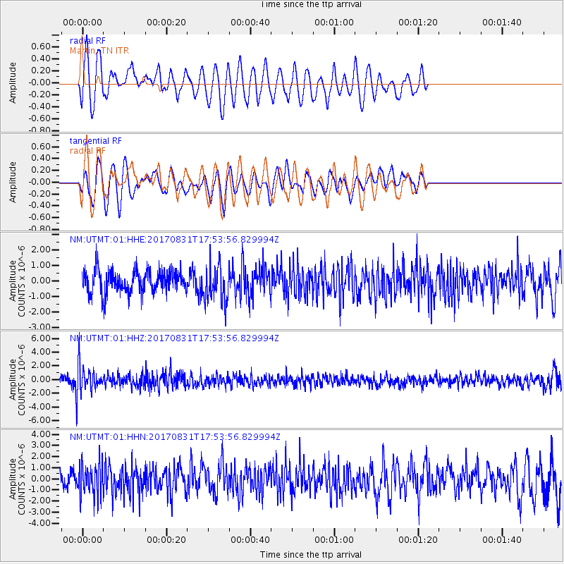
UTMT Martin, TN - Earthquake Result Viewer
*The percent match for this event was below the threshold and hence no stack was calculated.
| Earthquake location: |
Kodiak Island Region, Alaska |
| Earthquake latitude/longitude: |
58.5/-153.7 |
| Earthquake time(UTC): |
2017/08/31 (243) 17:46:02 GMT |
| Earthquake Depth: |
62 km |
| Earthquake Magnitude: |
5.5 ml |
| Earthquake Catalog/Contributor: |
NEIC PDE/ak |
|
| Network: |
NM Cooperative New Madrid Seismic Network |
| Station: |
UTMT Martin, TN |
| Lat/Lon: |
36.35 N/88.86 W |
| Elevation: |
110 m |
|
| Distance: |
46.9 deg |
| Az: |
88.608 deg |
| Baz: |
319.376 deg |
| Ray Param: |
$rayparam |
*The percent match for this event was below the threshold and hence was not used in the summary stack. |
|
| Radial Match: |
48.829357 % |
| Radial Bump: |
400 |
| Transverse Match: |
59.981384 % |
| Transverse Bump: |
400 |
| SOD ConfigId: |
2307692 |
| Insert Time: |
2017-09-14 17:53:35.781 +0000 |
| GWidth: |
2.5 |
| Max Bumps: |
400 |
| Tol: |
0.001 |
|
Signal To Noise
| Channel | StoN | STA | LTA |
| NM:UTMT:01:HHZ:20170831T17:53:56.829994Z | 3.2583992 | 1.7433788E-6 | 5.350415E-7 |
| NM:UTMT:01:HHN:20170831T17:53:56.829994Z | 1.4069908 | 1.4403566E-6 | 1.0237144E-6 |
| NM:UTMT:01:HHE:20170831T17:53:56.829994Z | 1.6669528 | 1.2012073E-6 | 7.206006E-7 |
| Arrivals |
| Ps | |
| PpPs | |
| PsPs/PpSs | |


