You are here: Home > Network List > GO - National Seismic Network of Georgia Stations List
> Station TBLG Delisi, Georgia > Earthquake Result Viewer
TBLG Delisi, Georgia - Earthquake Result Viewer
| Earthquake location: |
South Of Alaska |
| Earthquake latitude/longitude: |
54.8/-159.9 |
| Earthquake time(UTC): |
2020/10/06 (280) 05:54:50 GMT |
| Earthquake Depth: |
30 km |
| Earthquake Magnitude: |
5.6 ml |
| Earthquake Catalog/Contributor: |
NEIC PDE/us |
|
| Network: |
GO National Seismic Network of Georgia |
| Station: |
TBLG Delisi, Georgia |
| Lat/Lon: |
41.73 N/44.74 E |
| Elevation: |
510 m |
|
| Distance: |
81.5 deg |
| Az: |
341.639 deg |
| Baz: |
14.088 deg |
| Ray Param: |
0.04749048 |
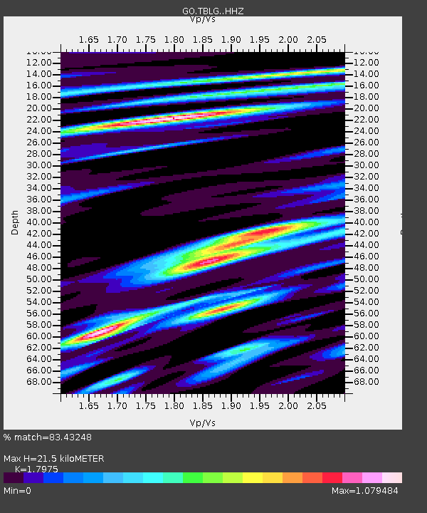
| Estimated Moho Depth: |
21.5 km |
| Estimated Crust Vp/Vs: |
1.80 |
| Assumed Crust Vp: |
6.291 km/s |
| Estimated Crust Vs: |
3.5 km/s |
| Estimated Crust Poisson's Ratio: |
0.28 |
|
| Radial Match: |
83.43248 % |
| Radial Bump: |
400 |
| Transverse Match: |
80.91253 % |
| Transverse Bump: |
400 |
| SOD ConfigId: |
22732711 |
| Insert Time: |
2020-10-20 06:02:06.009 +0000 |
| GWidth: |
2.5 |
| Max Bumps: |
400 |
| Tol: |
0.001 |
|
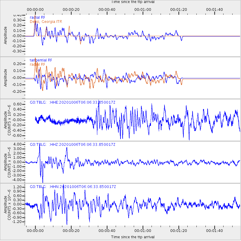
Signal To Noise
| Channel | StoN | STA | LTA |
| GO:TBLG: :HHZ:20201006T06:06:33.850017Z | 16.280394 | 1.712392E-6 | 1.05181236E-7 |
| GO:TBLG: :HHN:20201006T06:06:33.850017Z | 5.4699645 | 4.7457925E-7 | 8.676094E-8 |
| GO:TBLG: :HHE:20201006T06:06:33.850017Z | 1.9989778 | 1.611316E-7 | 8.0606995E-8 |
| Arrivals |
| Ps | 2.8 SECOND |
| PpPs | 9.3 SECOND |
| PsPs/PpSs | 12 SECOND |


