You are here: Home > Network List > N4 - Central and EAstern US Network Stations List
> Station S44A Carbondale, IL, USA > Earthquake Result Viewer
S44A Carbondale, IL, USA - Earthquake Result Viewer
| Earthquake location: |
South Of Alaska |
| Earthquake latitude/longitude: |
54.8/-159.9 |
| Earthquake time(UTC): |
2020/10/06 (280) 05:54:50 GMT |
| Earthquake Depth: |
30 km |
| Earthquake Magnitude: |
5.6 ml |
| Earthquake Catalog/Contributor: |
NEIC PDE/us |
|
| Network: |
N4 Central and EAstern US Network |
| Station: |
S44A Carbondale, IL, USA |
| Lat/Lon: |
37.69 N/89.26 W |
| Elevation: |
155 m |
|
| Distance: |
49.5 deg |
| Az: |
79.605 deg |
| Baz: |
314.181 deg |
| Ray Param: |
0.068604656 |
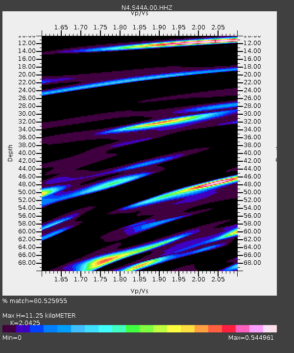
| Estimated Moho Depth: |
11.25 km |
| Estimated Crust Vp/Vs: |
2.04 |
| Assumed Crust Vp: |
6.444 km/s |
| Estimated Crust Vs: |
3.155 km/s |
| Estimated Crust Poisson's Ratio: |
0.34 |
|
| Radial Match: |
80.525955 % |
| Radial Bump: |
400 |
| Transverse Match: |
49.896114 % |
| Transverse Bump: |
400 |
| SOD ConfigId: |
22732711 |
| Insert Time: |
2020-10-20 06:08:12.192 +0000 |
| GWidth: |
2.5 |
| Max Bumps: |
400 |
| Tol: |
0.001 |
|

Signal To Noise
| Channel | StoN | STA | LTA |
| N4:S44A:00:HHZ:20201006T06:03:07.690013Z | 3.1976979 | 3.9621864E-7 | 1.2390747E-7 |
| N4:S44A:00:HH1:20201006T06:03:07.690013Z | 2.518716 | 2.5275676E-7 | 1.0035143E-7 |
| N4:S44A:00:HH2:20201006T06:03:07.690013Z | 1.5108215 | 1.9129467E-7 | 1.2661633E-7 |
| Arrivals |
| Ps | 1.9 SECOND |
| PpPs | 5.0 SECOND |
| PsPs/PpSs | 7.0 SECOND |


