You are here: Home > Network List > XT97 - Colorado BB Array - Lodore Stations List
> Station SMR XT.SMR > Earthquake Result Viewer
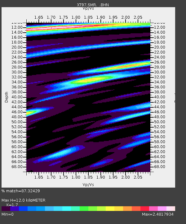
SMR XT.SMR - Earthquake Result Viewer
| Earthquake location: |
Southern Alaska |
| Earthquake latitude/longitude: |
60.5/-153.2 |
| Earthquake time(UTC): |
1998/07/09 (190) 19:39:43 GMT |
| Earthquake Depth: |
145 km |
| Earthquake Magnitude: |
5.3 MB, 6.2 UNKNOWN, 6.2 MW |
| Earthquake Catalog/Contributor: |
WHDF/NEIC |
|
| Network: |
XT Colorado BB Array - Lodore |
| Station: |
SMR XT.SMR |
| Lat/Lon: |
40.72 N/108.30 W |
| Elevation: |
1900 m |
|
| Distance: |
33.8 deg |
| Az: |
105.267 deg |
| Baz: |
321.125 deg |
| Ray Param: |
0.0775822 |
| Estimated Moho Depth: |
12.0 km |
| Estimated Crust Vp/Vs: |
1.70 |
| Assumed Crust Vp: |
6.207 km/s |
| Estimated Crust Vs: |
3.651 km/s |
| Estimated Crust Poisson's Ratio: |
0.24 |
|
| Radial Match: |
87.32429 % |
| Radial Bump: |
400 |
| Transverse Match: |
72.7502 % |
| Transverse Bump: |
400 |
| SOD ConfigId: |
4480 |
| Insert Time: |
2010-03-09 01:44:49.232 +0000 |
| GWidth: |
2.5 |
| Max Bumps: |
400 |
| Tol: |
0.001 |
|

Signal To Noise
| Channel | StoN | STA | LTA |
| XT:SMR: :BHN:19980709T19:45:41.750006Z | 3.760442 | 2.2688758E-7 | 6.0335346E-8 |
| XT:SMR: :BHE:19980709T19:45:41.750006Z | 0.7698711 | 7.6016306E-8 | 9.873901E-8 |
| XT:SMR: :BHZ:19980709T19:45:41.750006Z | 1.569015 | 9.938973E-8 | 6.3345304E-8 |
| Arrivals |
| Ps | 1.5 SECOND |
| PpPs | 4.8 SECOND |
| PsPs/PpSs | 6.3 SECOND |


