You are here: Home > Network List > XT97 - Colorado BB Array - Lodore Stations List
> Station SMR XT.SMR > Earthquake Result Viewer
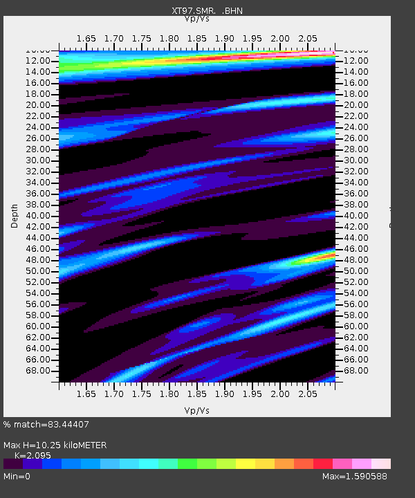
SMR XT.SMR - Earthquake Result Viewer
| Earthquake location: |
Near Coast Of Guatemala |
| Earthquake latitude/longitude: |
13.7/-90.7 |
| Earthquake time(UTC): |
1998/05/10 (130) 06:05:58 GMT |
| Earthquake Depth: |
33 km |
| Earthquake Magnitude: |
5.3 MB, 5.9 MS, 6.3 UNKNOWN, 5.3 MD |
| Earthquake Catalog/Contributor: |
WHDF/NEIC |
|
| Network: |
XT Colorado BB Array - Lodore |
| Station: |
SMR XT.SMR |
| Lat/Lon: |
40.72 N/108.30 W |
| Elevation: |
1900 m |
|
| Distance: |
31.0 deg |
| Az: |
333.58 deg |
| Baz: |
145.317 deg |
| Ray Param: |
0.07914991 |
| Estimated Moho Depth: |
10.25 km |
| Estimated Crust Vp/Vs: |
2.10 |
| Assumed Crust Vp: |
6.207 km/s |
| Estimated Crust Vs: |
2.963 km/s |
| Estimated Crust Poisson's Ratio: |
0.35 |
|
| Radial Match: |
83.44407 % |
| Radial Bump: |
356 |
| Transverse Match: |
63.169224 % |
| Transverse Bump: |
393 |
| SOD ConfigId: |
4480 |
| Insert Time: |
2010-03-09 01:44:53.687 +0000 |
| GWidth: |
2.5 |
| Max Bumps: |
400 |
| Tol: |
0.001 |
|

Signal To Noise
| Channel | StoN | STA | LTA |
| XT:SMR: :BHN:19980510T06:11:43.150Z | 2.948467 | 1.2864244E-6 | 4.363028E-7 |
| XT:SMR: :BHE:19980510T06:11:43.150Z | 1.4189992 | 2.8340327E-7 | 1.9972053E-7 |
| XT:SMR: :BHZ:19980510T06:11:43.150Z | 1.1654485 | 5.131412E-7 | 4.40295E-7 |
| Arrivals |
| Ps | 1.9 SECOND |
| PpPs | 4.8 SECOND |
| PsPs/PpSs | 6.7 SECOND |


