You are here: Home > Network List > TX - Texas Seismological Network Stations List
> Station BRDY Brady > Earthquake Result Viewer
BRDY Brady - Earthquake Result Viewer
| Earthquake location: |
South Of Alaska |
| Earthquake latitude/longitude: |
54.8/-159.9 |
| Earthquake time(UTC): |
2020/10/06 (280) 05:54:50 GMT |
| Earthquake Depth: |
30 km |
| Earthquake Magnitude: |
5.6 ml |
| Earthquake Catalog/Contributor: |
NEIC PDE/us |
|
| Network: |
TX Texas Seismological Network |
| Station: |
BRDY Brady |
| Lat/Lon: |
31.27 N/99.00 W |
| Elevation: |
460 m |
|
| Distance: |
48.5 deg |
| Az: |
93.171 deg |
| Baz: |
317.589 deg |
| Ray Param: |
0.06926679 |
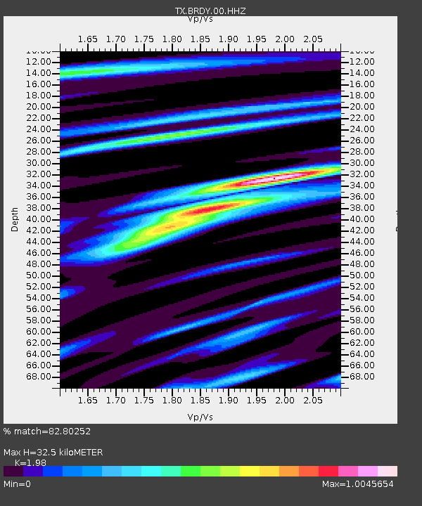
| Estimated Moho Depth: |
32.5 km |
| Estimated Crust Vp/Vs: |
1.98 |
| Assumed Crust Vp: |
6.498 km/s |
| Estimated Crust Vs: |
3.282 km/s |
| Estimated Crust Poisson's Ratio: |
0.33 |
|
| Radial Match: |
82.80252 % |
| Radial Bump: |
380 |
| Transverse Match: |
63.211758 % |
| Transverse Bump: |
400 |
| SOD ConfigId: |
22732711 |
| Insert Time: |
2020-10-20 06:14:31.014 +0000 |
| GWidth: |
2.5 |
| Max Bumps: |
400 |
| Tol: |
0.001 |
|

Signal To Noise
| Channel | StoN | STA | LTA |
| TX:BRDY:00:HHZ:20201006T06:02:59.785015Z | 2.366126 | 1.6978015E-7 | 7.1754485E-8 |
| TX:BRDY:00:HH1:20201006T06:02:59.785015Z | 0.8329077 | 5.843583E-8 | 7.015883E-8 |
| TX:BRDY:00:HH2:20201006T06:02:59.785015Z | 2.018977 | 9.829636E-8 | 4.868622E-8 |
| Arrivals |
| Ps | 5.2 SECOND |
| PpPs | 14 SECOND |
| PsPs/PpSs | 19 SECOND |


