You are here: Home > Network List > UU - University of Utah Regional Network Stations List
> Station KNB Kanab, UT, USA > Earthquake Result Viewer
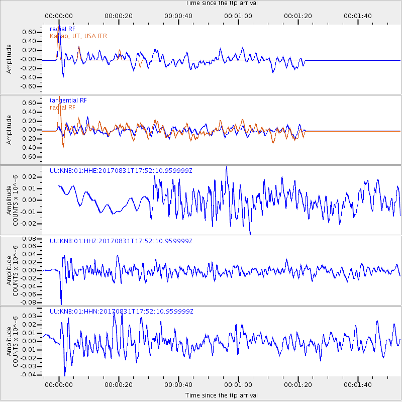
KNB Kanab, UT, USA - Earthquake Result Viewer
*The percent match for this event was below the threshold and hence no stack was calculated.
| Earthquake location: |
Kodiak Island Region, Alaska |
| Earthquake latitude/longitude: |
58.5/-153.7 |
| Earthquake time(UTC): |
2017/08/31 (243) 17:46:02 GMT |
| Earthquake Depth: |
62 km |
| Earthquake Magnitude: |
5.5 ml |
| Earthquake Catalog/Contributor: |
NEIC PDE/ak |
|
| Network: |
UU University of Utah Regional Network |
| Station: |
KNB Kanab, UT, USA |
| Lat/Lon: |
37.02 N/112.82 W |
| Elevation: |
1715 m |
|
| Distance: |
34.1 deg |
| Az: |
110.914 deg |
| Baz: |
322.148 deg |
| Ray Param: |
$rayparam |
*The percent match for this event was below the threshold and hence was not used in the summary stack. |
|
| Radial Match: |
57.980762 % |
| Radial Bump: |
321 |
| Transverse Match: |
57.513718 % |
| Transverse Bump: |
382 |
| SOD ConfigId: |
2307692 |
| Insert Time: |
2017-09-14 17:54:51.537 +0000 |
| GWidth: |
2.5 |
| Max Bumps: |
400 |
| Tol: |
0.001 |
|
Signal To Noise
| Channel | StoN | STA | LTA |
| UU:KNB:01:HHZ:20170831T17:52:10.959999Z | 5.1562786 | 2.7420793E-8 | 5.3179425E-9 |
| UU:KNB:01:HHN:20170831T17:52:10.959999Z | 1.8907521 | 1.8171427E-8 | 9.610687E-9 |
| UU:KNB:01:HHE:20170831T17:52:10.959999Z | 1.4832604 | 1.0517004E-8 | 7.0904638E-9 |
| Arrivals |
| Ps | |
| PpPs | |
| PsPs/PpSs | |


