You are here: Home > Network List > WY - Yellowstone Wyoming Seismic Network Stations List
> Station YHH Holmes Hill, YNP, WY, USA > Earthquake Result Viewer
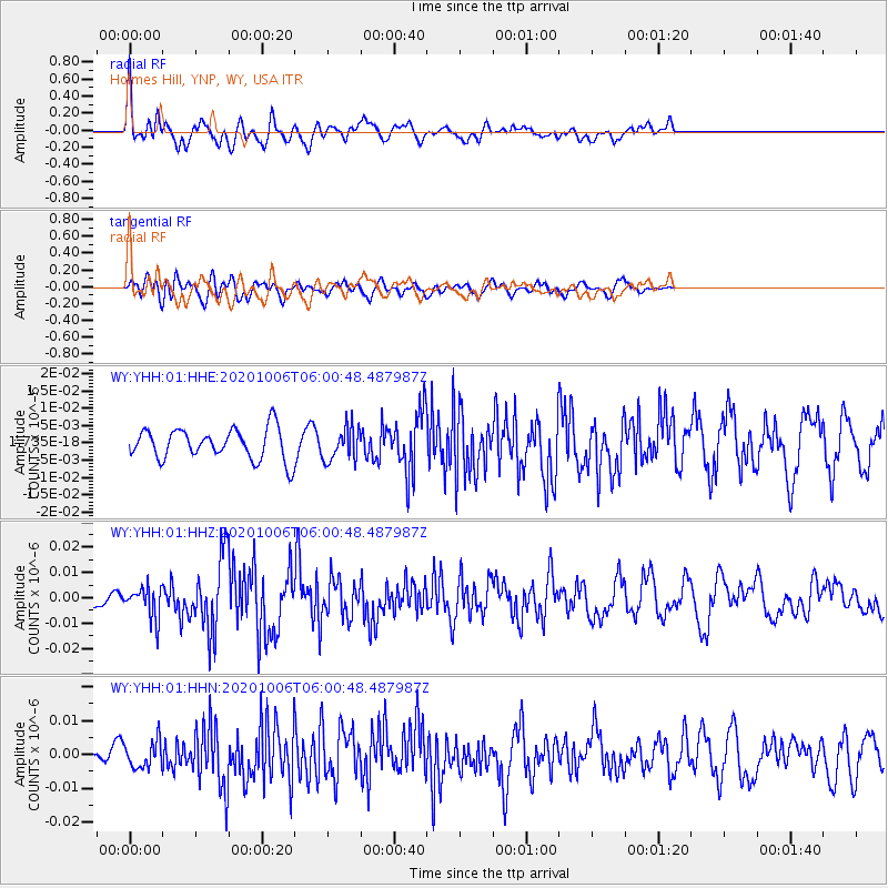
YHH Holmes Hill, YNP, WY, USA - Earthquake Result Viewer
*The percent match for this event was below the threshold and hence no stack was calculated.
| Earthquake location: |
South Of Alaska |
| Earthquake latitude/longitude: |
54.8/-159.9 |
| Earthquake time(UTC): |
2020/10/06 (280) 05:54:50 GMT |
| Earthquake Depth: |
30 km |
| Earthquake Magnitude: |
5.6 ml |
| Earthquake Catalog/Contributor: |
NEIC PDE/us |
|
| Network: |
WY Yellowstone Wyoming Seismic Network |
| Station: |
YHH Holmes Hill, YNP, WY, USA |
| Lat/Lon: |
44.79 N/110.85 W |
| Elevation: |
2717 m |
|
| Distance: |
32.6 deg |
| Az: |
87.331 deg |
| Baz: |
305.77 deg |
| Ray Param: |
$rayparam |
*The percent match for this event was below the threshold and hence was not used in the summary stack. |
|
| Radial Match: |
78.58035 % |
| Radial Bump: |
400 |
| Transverse Match: |
70.54691 % |
| Transverse Bump: |
400 |
| SOD ConfigId: |
22732711 |
| Insert Time: |
2020-10-20 06:17:39.352 +0000 |
| GWidth: |
2.5 |
| Max Bumps: |
400 |
| Tol: |
0.001 |
|
Signal To Noise
| Channel | StoN | STA | LTA |
| WY:YHH:01:HHZ:20201006T06:00:48.487987Z | 2.8973129 | 6.141149E-9 | 2.1196014E-9 |
| WY:YHH:01:HHN:20201006T06:00:48.487987Z | 1.244983 | 3.984761E-9 | 3.200655E-9 |
| WY:YHH:01:HHE:20201006T06:00:48.487987Z | 1.0797911 | 4.814137E-9 | 4.4583968E-9 |
| Arrivals |
| Ps | |
| PpPs | |
| PsPs/PpSs | |


