You are here: Home > Network List > AK - Alaska Regional Network Stations List
> Station O19K Port Alsworth, AK, USA > Earthquake Result Viewer
O19K Port Alsworth, AK, USA - Earthquake Result Viewer
| Earthquake location: |
Fiji Islands Region |
| Earthquake latitude/longitude: |
-18.0/-178.5 |
| Earthquake time(UTC): |
2020/10/06 (280) 10:11:46 GMT |
| Earthquake Depth: |
629 km |
| Earthquake Magnitude: |
6.0 Mww |
| Earthquake Catalog/Contributor: |
NEIC PDE/us |
|
| Network: |
AK Alaska Regional Network |
| Station: |
O19K Port Alsworth, AK, USA |
| Lat/Lon: |
60.20 N/154.32 W |
| Elevation: |
96 m |
|
| Distance: |
80.4 deg |
| Az: |
11.974 deg |
| Baz: |
203.277 deg |
| Ray Param: |
0.046360448 |
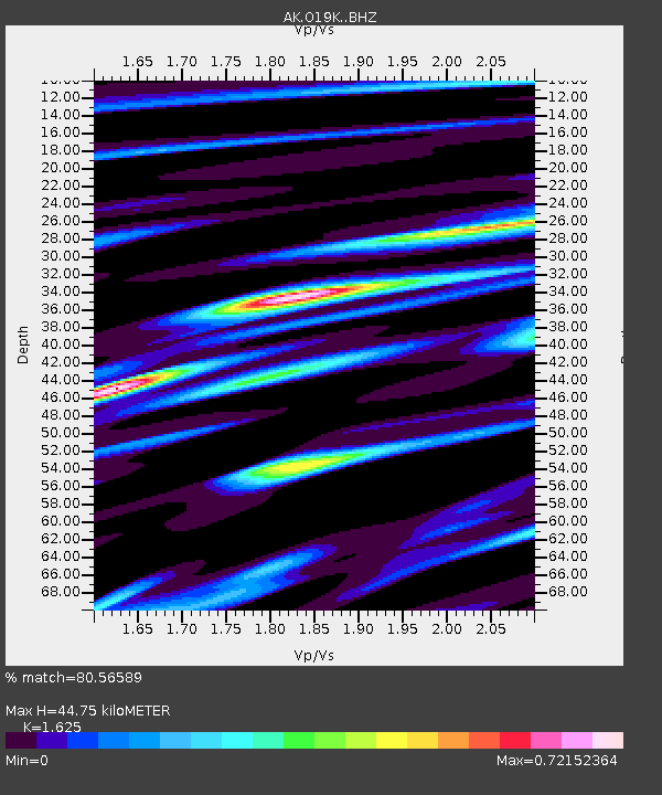
| Estimated Moho Depth: |
44.75 km |
| Estimated Crust Vp/Vs: |
1.62 |
| Assumed Crust Vp: |
6.566 km/s |
| Estimated Crust Vs: |
4.041 km/s |
| Estimated Crust Poisson's Ratio: |
0.20 |
|
| Radial Match: |
80.56589 % |
| Radial Bump: |
395 |
| Transverse Match: |
68.3047 % |
| Transverse Bump: |
400 |
| SOD ConfigId: |
22732711 |
| Insert Time: |
2020-10-20 10:15:08.375 +0000 |
| GWidth: |
2.5 |
| Max Bumps: |
400 |
| Tol: |
0.001 |
|

Signal To Noise
| Channel | StoN | STA | LTA |
| AK:O19K: :BHZ:20201006T10:22:22.800023Z | 19.877201 | 3.6300225E-6 | 1.8262243E-7 |
| AK:O19K: :BHN:20201006T10:22:22.800023Z | 13.28765 | 2.47052E-6 | 1.8592604E-7 |
| AK:O19K: :BHE:20201006T10:22:22.800023Z | 13.742701 | 2.183325E-6 | 1.5887161E-7 |
| Arrivals |
| Ps | 4.4 SECOND |
| PpPs | 17 SECOND |
| PsPs/PpSs | 22 SECOND |


