You are here: Home > Network List > AV - Alaska Volcano Observatory Stations List
> Station SPBG Barrier Glacier, Mount Spurr, Alaska > Earthquake Result Viewer
SPBG Barrier Glacier, Mount Spurr, Alaska - Earthquake Result Viewer
| Earthquake location: |
Fiji Islands Region |
| Earthquake latitude/longitude: |
-18.0/-178.5 |
| Earthquake time(UTC): |
2020/10/06 (280) 10:11:46 GMT |
| Earthquake Depth: |
629 km |
| Earthquake Magnitude: |
6.0 Mww |
| Earthquake Catalog/Contributor: |
NEIC PDE/us |
|
| Network: |
AV Alaska Volcano Observatory |
| Station: |
SPBG Barrier Glacier, Mount Spurr, Alaska |
| Lat/Lon: |
61.26 N/152.37 W |
| Elevation: |
1087 m |
|
| Distance: |
81.7 deg |
| Az: |
12.416 deg |
| Baz: |
205.042 deg |
| Ray Param: |
0.045447413 |
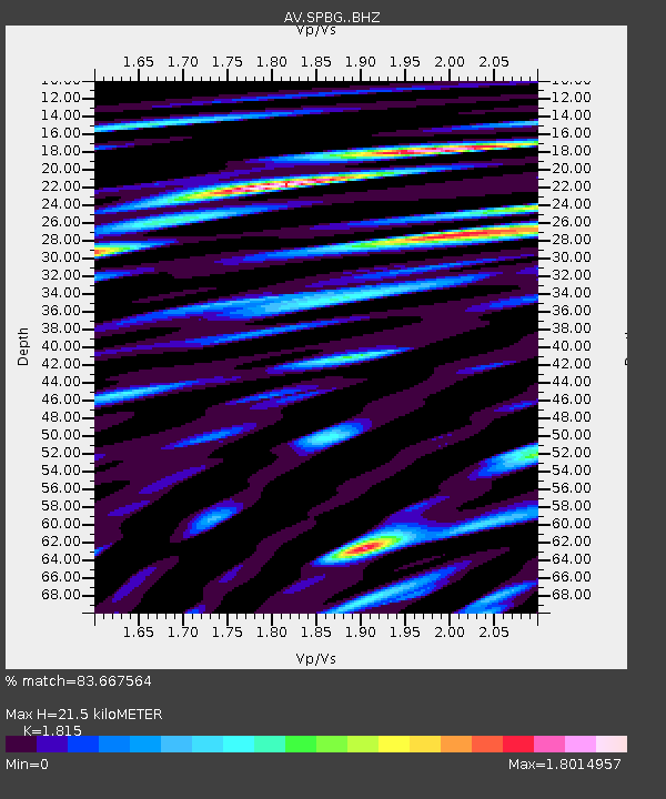
| Estimated Moho Depth: |
21.5 km |
| Estimated Crust Vp/Vs: |
1.82 |
| Assumed Crust Vp: |
6.566 km/s |
| Estimated Crust Vs: |
3.618 km/s |
| Estimated Crust Poisson's Ratio: |
0.28 |
|
| Radial Match: |
83.667564 % |
| Radial Bump: |
400 |
| Transverse Match: |
87.71106 % |
| Transverse Bump: |
400 |
| SOD ConfigId: |
22732711 |
| Insert Time: |
2020-10-20 10:19:39.938 +0000 |
| GWidth: |
2.5 |
| Max Bumps: |
400 |
| Tol: |
0.001 |
|

Signal To Noise
| Channel | StoN | STA | LTA |
| AV:SPBG: :BHZ:20201006T10:22:29.740026Z | 22.939207 | 2.2034717E-6 | 9.605701E-8 |
| AV:SPBG: :BHN:20201006T10:22:29.740026Z | 29.155268 | 3.0487352E-6 | 1.0456893E-7 |
| AV:SPBG: :BHE:20201006T10:22:29.740026Z | 33.329075 | 2.906084E-6 | 8.719366E-8 |
| Arrivals |
| Ps | 2.7 SECOND |
| PpPs | 9.0 SECOND |
| PsPs/PpSs | 12 SECOND |


