You are here: Home > Network List > CC - Cascade Chain Volcano Monitoring Stations List
> Station CLBH Crater Lake, OR, USA > Earthquake Result Viewer
CLBH Crater Lake, OR, USA - Earthquake Result Viewer
| Earthquake location: |
Fiji Islands Region |
| Earthquake latitude/longitude: |
-18.0/-178.5 |
| Earthquake time(UTC): |
2020/10/06 (280) 10:11:46 GMT |
| Earthquake Depth: |
629 km |
| Earthquake Magnitude: |
6.0 Mww |
| Earthquake Catalog/Contributor: |
NEIC PDE/us |
|
| Network: |
CC Cascade Chain Volcano Monitoring |
| Station: |
CLBH Crater Lake, OR, USA |
| Lat/Lon: |
42.91 N/122.14 W |
| Elevation: |
2197 m |
|
| Distance: |
79.7 deg |
| Az: |
38.434 deg |
| Baz: |
233.614 deg |
| Ray Param: |
0.046805557 |
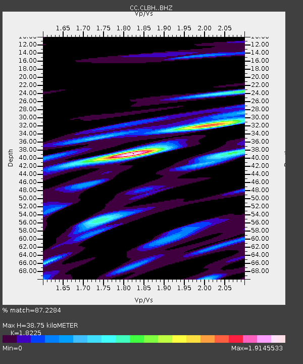
| Estimated Moho Depth: |
38.75 km |
| Estimated Crust Vp/Vs: |
1.82 |
| Assumed Crust Vp: |
6.522 km/s |
| Estimated Crust Vs: |
3.578 km/s |
| Estimated Crust Poisson's Ratio: |
0.28 |
|
| Radial Match: |
87.2284 % |
| Radial Bump: |
400 |
| Transverse Match: |
80.99229 % |
| Transverse Bump: |
400 |
| SOD ConfigId: |
22732711 |
| Insert Time: |
2020-10-20 10:21:51.360 +0000 |
| GWidth: |
2.5 |
| Max Bumps: |
400 |
| Tol: |
0.001 |
|

Signal To Noise
| Channel | StoN | STA | LTA |
| CC:CLBH: :BHZ:20201006T10:22:19.324987Z | 29.083984 | 3.7551624E-6 | 1.2911444E-7 |
| CC:CLBH: :BHN:20201006T10:22:19.324987Z | 8.045749 | 2.5937964E-6 | 3.2238097E-7 |
| CC:CLBH: :BHE:20201006T10:22:19.324987Z | 13.358516 | 2.8896025E-6 | 2.1631163E-7 |
| Arrivals |
| Ps | 5.0 SECOND |
| PpPs | 16 SECOND |
| PsPs/PpSs | 21 SECOND |


