You are here: Home > Network List > GS - US Geological Survey Networks Stations List
> Station ASA3 ASA3 > Earthquake Result Viewer
ASA3 ASA3 - Earthquake Result Viewer
| Earthquake location: |
Fiji Islands Region |
| Earthquake latitude/longitude: |
-18.0/-178.5 |
| Earthquake time(UTC): |
2020/10/06 (280) 10:11:46 GMT |
| Earthquake Depth: |
629 km |
| Earthquake Magnitude: |
6.0 Mww |
| Earthquake Catalog/Contributor: |
NEIC PDE/us |
|
| Network: |
GS US Geological Survey Networks |
| Station: |
ASA3 ASA3 |
| Lat/Lon: |
34.95 N/106.46 W |
| Elevation: |
1819 m |
|
| Distance: |
86.2 deg |
| Az: |
51.547 deg |
| Baz: |
245.104 deg |
| Ray Param: |
0.042350184 |
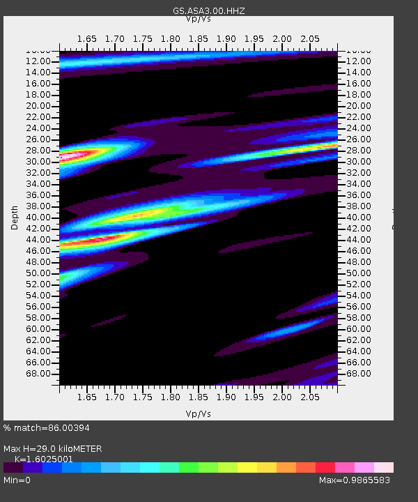
| Estimated Moho Depth: |
29.0 km |
| Estimated Crust Vp/Vs: |
1.60 |
| Assumed Crust Vp: |
6.502 km/s |
| Estimated Crust Vs: |
4.057 km/s |
| Estimated Crust Poisson's Ratio: |
0.18 |
|
| Radial Match: |
86.00394 % |
| Radial Bump: |
400 |
| Transverse Match: |
70.6822 % |
| Transverse Bump: |
400 |
| SOD ConfigId: |
22732711 |
| Insert Time: |
2020-10-20 10:26:24.791 +0000 |
| GWidth: |
2.5 |
| Max Bumps: |
400 |
| Tol: |
0.001 |
|

Signal To Noise
| Channel | StoN | STA | LTA |
| GS:ASA3:00:HHZ:20201006T10:22:51.618993Z | 17.970373 | 1.2551235E-6 | 6.984404E-8 |
| GS:ASA3:00:HH1:20201006T10:22:51.618993Z | 5.7285333 | 3.032026E-7 | 5.2928485E-8 |
| GS:ASA3:00:HH2:20201006T10:22:51.618993Z | 7.5247817 | 3.4873554E-7 | 4.6344937E-8 |
| Arrivals |
| Ps | 2.8 SECOND |
| PpPs | 11 SECOND |
| PsPs/PpSs | 14 SECOND |


