You are here: Home > Network List > XT97 - Colorado BB Array - Lodore Stations List
> Station TANK XT.TANK > Earthquake Result Viewer
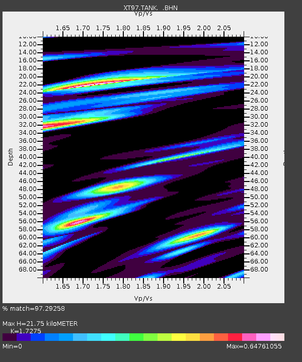
TANK XT.TANK - Earthquake Result Viewer
| Earthquake location: |
South Of Fiji Islands |
| Earthquake latitude/longitude: |
-22.1/-176.8 |
| Earthquake time(UTC): |
1997/10/14 (287) 09:53:18 GMT |
| Earthquake Depth: |
167 km |
| Earthquake Magnitude: |
6.7 MB, 7.7 UNKNOWN, 7.4 ME |
| Earthquake Catalog/Contributor: |
WHDF/NEIC |
|
| Network: |
XT Colorado BB Array - Lodore |
| Station: |
TANK XT.TANK |
| Lat/Lon: |
40.41 N/108.74 W |
| Elevation: |
2441 m |
|
| Distance: |
88.7 deg |
| Az: |
45.104 deg |
| Baz: |
239.352 deg |
| Ray Param: |
0.042048436 |
| Estimated Moho Depth: |
21.75 km |
| Estimated Crust Vp/Vs: |
1.73 |
| Assumed Crust Vp: |
6.207 km/s |
| Estimated Crust Vs: |
3.593 km/s |
| Estimated Crust Poisson's Ratio: |
0.25 |
|
| Radial Match: |
97.29258 % |
| Radial Bump: |
400 |
| Transverse Match: |
96.50179 % |
| Transverse Bump: |
400 |
| SOD ConfigId: |
6273 |
| Insert Time: |
2010-03-09 01:47:12.772 +0000 |
| GWidth: |
2.5 |
| Max Bumps: |
400 |
| Tol: |
0.001 |
|

Signal To Noise
| Channel | StoN | STA | LTA |
| XT:TANK: :BHN:19971014T10:05:21.125024Z | 1.290195 | 2.7214242E-7 | 2.1093125E-7 |
| XT:TANK: :BHE:19971014T10:05:21.125024Z | 4.691208 | 5.0270756E-7 | 1.07159515E-7 |
| XT:TANK: :BHZ:19971014T10:05:21.125024Z | 6.4448223 | 1.4320299E-6 | 2.2219851E-7 |
| Arrivals |
| Ps | 2.6 SECOND |
| PpPs | 9.4 SECOND |
| PsPs/PpSs | 12 SECOND |


