You are here: Home > Network List > XT97 - Colorado BB Array - Lodore Stations List
> Station TANK XT.TANK > Earthquake Result Viewer
TANK XT.TANK - Earthquake Result Viewer
| Earthquake location: |
South Of Fiji Islands |
| Earthquake latitude/longitude: |
-22.2/-179.5 |
| Earthquake time(UTC): |
1998/05/16 (136) 02:22:03 GMT |
| Earthquake Depth: |
586 km |
| Earthquake Magnitude: |
6.1 MB, 6.8 UNKNOWN |
| Earthquake Catalog/Contributor: |
WHDF/NEIC |
|
| Network: |
XT Colorado BB Array - Lodore |
| Station: |
TANK XT.TANK |
| Lat/Lon: |
40.41 N/108.74 W |
| Elevation: |
2441 m |
|
| Distance: |
90.6 deg |
| Az: |
46.146 deg |
| Baz: |
241.043 deg |
| Ray Param: |
0.041384622 |
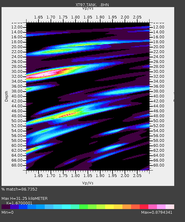
| Estimated Moho Depth: |
31.25 km |
| Estimated Crust Vp/Vs: |
1.67 |
| Assumed Crust Vp: |
6.207 km/s |
| Estimated Crust Vs: |
3.717 km/s |
| Estimated Crust Poisson's Ratio: |
0.22 |
|
| Radial Match: |
86.7352 % |
| Radial Bump: |
400 |
| Transverse Match: |
67.78744 % |
| Transverse Bump: |
400 |
| SOD ConfigId: |
4480 |
| Insert Time: |
2010-03-09 01:47:22.494 +0000 |
| GWidth: |
2.5 |
| Max Bumps: |
400 |
| Tol: |
0.001 |
|

Signal To Noise
| Channel | StoN | STA | LTA |
| XT:TANK: :BHN:19980516T02:33:32.325Z | 21.055113 | 1.7422437E-6 | 8.274682E-8 |
| XT:TANK: :BHE:19980516T02:33:32.325Z | 1.976806 | 1.97156E-7 | 9.973462E-8 |
| XT:TANK: :BHZ:19980516T02:33:32.325Z | 12.903898 | 5.526288E-7 | 4.2826503E-8 |
| Arrivals |
| Ps | 3.4 SECOND |
| PpPs | 13 SECOND |
| PsPs/PpSs | 17 SECOND |


