You are here: Home > Network List > XT97 - Colorado BB Array - Lodore Stations List
> Station TANK XT.TANK > Earthquake Result Viewer
TANK XT.TANK - Earthquake Result Viewer
| Earthquake location: |
Southern Alaska |
| Earthquake latitude/longitude: |
60.5/-153.2 |
| Earthquake time(UTC): |
1998/07/09 (190) 19:39:43 GMT |
| Earthquake Depth: |
145 km |
| Earthquake Magnitude: |
5.3 MB, 6.2 UNKNOWN, 6.2 MW |
| Earthquake Catalog/Contributor: |
WHDF/NEIC |
|
| Network: |
XT Colorado BB Array - Lodore |
| Station: |
TANK XT.TANK |
| Lat/Lon: |
40.41 N/108.74 W |
| Elevation: |
2441 m |
|
| Distance: |
33.8 deg |
| Az: |
106.086 deg |
| Baz: |
321.524 deg |
| Ray Param: |
0.077561714 |
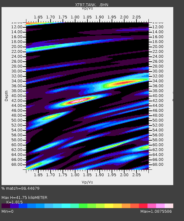
| Estimated Moho Depth: |
41.75 km |
| Estimated Crust Vp/Vs: |
1.82 |
| Assumed Crust Vp: |
6.207 km/s |
| Estimated Crust Vs: |
3.42 km/s |
| Estimated Crust Poisson's Ratio: |
0.28 |
|
| Radial Match: |
86.44679 % |
| Radial Bump: |
400 |
| Transverse Match: |
72.272545 % |
| Transverse Bump: |
400 |
| SOD ConfigId: |
4480 |
| Insert Time: |
2010-03-09 01:47:25.984 +0000 |
| GWidth: |
2.5 |
| Max Bumps: |
400 |
| Tol: |
0.001 |
|

Signal To Noise
| Channel | StoN | STA | LTA |
| XT:TANK: :BHN:19980709T19:45:42.100012Z | 4.1449175 | 2.6350114E-7 | 6.35721E-8 |
| XT:TANK: :BHE:19980709T19:45:42.100012Z | 2.9937882 | 1.2771636E-7 | 4.2660453E-8 |
| XT:TANK: :BHZ:19980709T19:45:42.100012Z | 1.0806686 | 9.482877E-8 | 8.7750095E-8 |
| Arrivals |
| Ps | 5.9 SECOND |
| PpPs | 18 SECOND |
| PsPs/PpSs | 24 SECOND |


