You are here: Home > Network List > XT97 - Colorado BB Array - Lodore Stations List
> Station TANK XT.TANK > Earthquake Result Viewer
TANK XT.TANK - Earthquake Result Viewer
| Earthquake location: |
Fiji Islands Region |
| Earthquake latitude/longitude: |
-17.6/-179.1 |
| Earthquake time(UTC): |
1998/03/29 (088) 19:48:16 GMT |
| Earthquake Depth: |
537 km |
| Earthquake Magnitude: |
6.5 MB, 7.2 UNKNOWN, 7.1 MW |
| Earthquake Catalog/Contributor: |
WHDF/NEIC |
|
| Network: |
XT Colorado BB Array - Lodore |
| Station: |
TANK XT.TANK |
| Lat/Lon: |
40.41 N/108.74 W |
| Elevation: |
2441 m |
|
| Distance: |
87.1 deg |
| Az: |
46.065 deg |
| Baz: |
244.116 deg |
| Ray Param: |
0.04210019 |
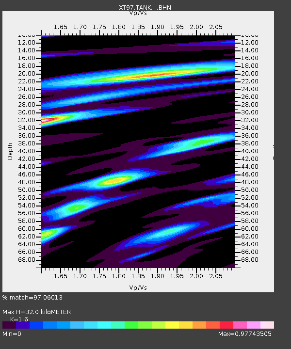
| Estimated Moho Depth: |
32.0 km |
| Estimated Crust Vp/Vs: |
1.60 |
| Assumed Crust Vp: |
6.207 km/s |
| Estimated Crust Vs: |
3.879 km/s |
| Estimated Crust Poisson's Ratio: |
0.18 |
|
| Radial Match: |
97.06013 % |
| Radial Bump: |
311 |
| Transverse Match: |
92.61277 % |
| Transverse Bump: |
336 |
| SOD ConfigId: |
4480 |
| Insert Time: |
2010-03-09 01:47:37.514 +0000 |
| GWidth: |
2.5 |
| Max Bumps: |
400 |
| Tol: |
0.001 |
|

Signal To Noise
| Channel | StoN | STA | LTA |
| XT:TANK: :BHN:19980329T19:59:33.450Z | 133.03859 | 1.4210287E-5 | 1.06813275E-7 |
| XT:TANK: :BHE:19980329T19:59:33.450Z | 8.1945505 | 1.3155902E-6 | 1.6054452E-7 |
| XT:TANK: :BHZ:19980329T19:59:33.450Z | 27.432436 | 4.4813305E-6 | 1.6335882E-7 |
| Arrivals |
| Ps | 3.2 SECOND |
| PpPs | 13 SECOND |
| PsPs/PpSs | 16 SECOND |


