You are here: Home > Network List > TA - USArray Transportable Network (new EarthScope stations) Stations List
> Station G31M Satah River, YT, CAN > Earthquake Result Viewer
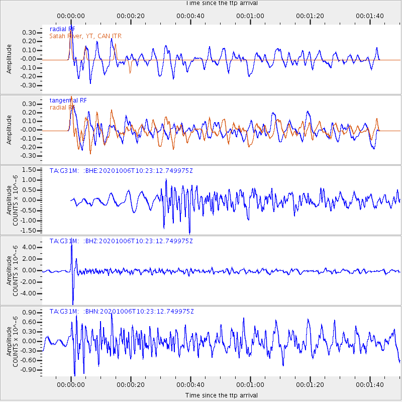
G31M Satah River, YT, CAN - Earthquake Result Viewer
*The percent match for this event was below the threshold and hence no stack was calculated.
| Earthquake location: |
Fiji Islands Region |
| Earthquake latitude/longitude: |
-18.0/-178.5 |
| Earthquake time(UTC): |
2020/10/06 (280) 10:11:46 GMT |
| Earthquake Depth: |
629 km |
| Earthquake Magnitude: |
6.0 Mww |
| Earthquake Catalog/Contributor: |
NEIC PDE/us |
|
| Network: |
TA USArray Transportable Network (new EarthScope stations) |
| Station: |
G31M Satah River, YT, CAN |
| Lat/Lon: |
66.92 N/134.27 W |
| Elevation: |
61 m |
|
| Distance: |
90.8 deg |
| Az: |
15.959 deg |
| Baz: |
221.581 deg |
| Ray Param: |
$rayparam |
*The percent match for this event was below the threshold and hence was not used in the summary stack. |
|
| Radial Match: |
66.902245 % |
| Radial Bump: |
400 |
| Transverse Match: |
49.6998 % |
| Transverse Bump: |
400 |
| SOD ConfigId: |
22732711 |
| Insert Time: |
2020-10-20 10:35:23.892 +0000 |
| GWidth: |
2.5 |
| Max Bumps: |
400 |
| Tol: |
0.001 |
|
Signal To Noise
| Channel | StoN | STA | LTA |
| TA:G31M: :BHZ:20201006T10:23:12.749975Z | 17.865105 | 1.8855865E-6 | 1.0554579E-7 |
| TA:G31M: :BHN:20201006T10:23:12.749975Z | 3.1959002 | 4.6496842E-7 | 1.4548904E-7 |
| TA:G31M: :BHE:20201006T10:23:12.749975Z | 2.360365 | 5.4194993E-7 | 2.2960428E-7 |
| Arrivals |
| Ps | |
| PpPs | |
| PsPs/PpSs | |


