You are here: Home > Network List > TA - USArray Transportable Network (new EarthScope stations) Stations List
> Station I17K Unalakleet, AK, USA > Earthquake Result Viewer
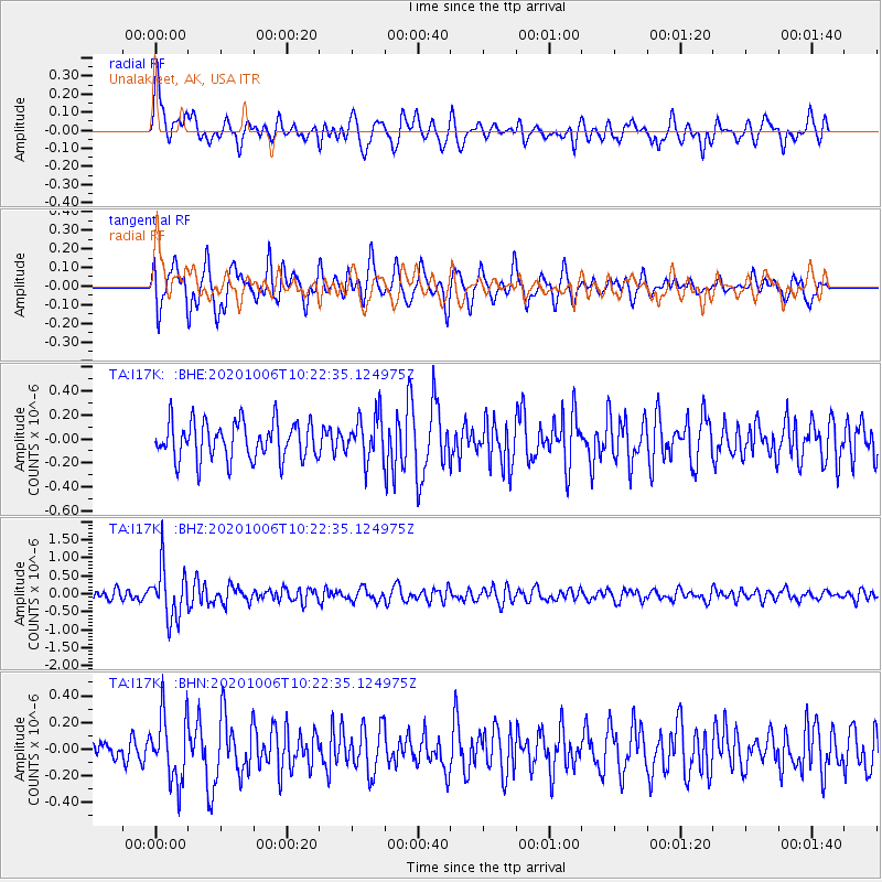
I17K Unalakleet, AK, USA - Earthquake Result Viewer
*The percent match for this event was below the threshold and hence no stack was calculated.
| Earthquake location: |
Fiji Islands Region |
| Earthquake latitude/longitude: |
-18.0/-178.5 |
| Earthquake time(UTC): |
2020/10/06 (280) 10:11:46 GMT |
| Earthquake Depth: |
629 km |
| Earthquake Magnitude: |
6.0 Mww |
| Earthquake Catalog/Contributor: |
NEIC PDE/us |
|
| Network: |
TA USArray Transportable Network (new EarthScope stations) |
| Station: |
I17K Unalakleet, AK, USA |
| Lat/Lon: |
63.89 N/160.70 W |
| Elevation: |
105 m |
|
| Distance: |
82.8 deg |
| Az: |
7.835 deg |
| Baz: |
197.044 deg |
| Ray Param: |
$rayparam |
*The percent match for this event was below the threshold and hence was not used in the summary stack. |
|
| Radial Match: |
65.91005 % |
| Radial Bump: |
400 |
| Transverse Match: |
63.238308 % |
| Transverse Bump: |
400 |
| SOD ConfigId: |
22732711 |
| Insert Time: |
2020-10-20 10:35:31.160 +0000 |
| GWidth: |
2.5 |
| Max Bumps: |
400 |
| Tol: |
0.001 |
|
Signal To Noise
| Channel | StoN | STA | LTA |
| TA:I17K: :BHZ:20201006T10:22:35.124975Z | 4.2926598 | 7.254031E-7 | 1.6898686E-7 |
| TA:I17K: :BHN:20201006T10:22:35.124975Z | 2.3682697 | 2.5144377E-7 | 1.0617193E-7 |
| TA:I17K: :BHE:20201006T10:22:35.124975Z | 1.1681099 | 1.8271E-7 | 1.5641508E-7 |
| Arrivals |
| Ps | |
| PpPs | |
| PsPs/PpSs | |


