You are here: Home > Network List > TA - USArray Transportable Network (new EarthScope stations) Stations List
> Station M31M Drury Creek, Yukon, CA > Earthquake Result Viewer
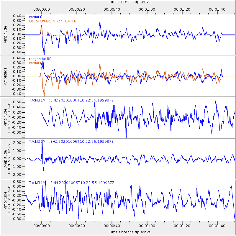
M31M Drury Creek, Yukon, CA - Earthquake Result Viewer
*The percent match for this event was below the threshold and hence no stack was calculated.
| Earthquake location: |
Fiji Islands Region |
| Earthquake latitude/longitude: |
-18.0/-178.5 |
| Earthquake time(UTC): |
2020/10/06 (280) 10:11:46 GMT |
| Earthquake Depth: |
629 km |
| Earthquake Magnitude: |
6.0 Mww |
| Earthquake Catalog/Contributor: |
NEIC PDE/us |
|
| Network: |
TA USArray Transportable Network (new EarthScope stations) |
| Station: |
M31M Drury Creek, Yukon, CA |
| Lat/Lon: |
62.20 N/134.39 W |
| Elevation: |
639 m |
|
| Distance: |
87.2 deg |
| Az: |
19.065 deg |
| Baz: |
221.527 deg |
| Ray Param: |
$rayparam |
*The percent match for this event was below the threshold and hence was not used in the summary stack. |
|
| Radial Match: |
64.43775 % |
| Radial Bump: |
400 |
| Transverse Match: |
72.97177 % |
| Transverse Bump: |
400 |
| SOD ConfigId: |
22732711 |
| Insert Time: |
2020-10-20 10:36:04.524 +0000 |
| GWidth: |
2.5 |
| Max Bumps: |
400 |
| Tol: |
0.001 |
|
Signal To Noise
| Channel | StoN | STA | LTA |
| TA:M31M: :BHZ:20201006T10:22:56.199987Z | 6.4151073 | 7.5789643E-7 | 1.18142445E-7 |
| TA:M31M: :BHN:20201006T10:22:56.199987Z | 2.7377706 | 3.7257203E-7 | 1.3608593E-7 |
| TA:M31M: :BHE:20201006T10:22:56.199987Z | 1.2363186 | 2.6341388E-7 | 2.1306312E-7 |
| Arrivals |
| Ps | |
| PpPs | |
| PsPs/PpSs | |


