You are here: Home > Network List > TX - Texas Seismological Network Stations List
> Station 833A Chaparral WMA, Artesia Wells, TX, USA > Earthquake Result Viewer
833A Chaparral WMA, Artesia Wells, TX, USA - Earthquake Result Viewer
| Earthquake location: |
Fiji Islands Region |
| Earthquake latitude/longitude: |
-18.0/-178.5 |
| Earthquake time(UTC): |
2020/10/06 (280) 10:11:46 GMT |
| Earthquake Depth: |
629 km |
| Earthquake Magnitude: |
6.0 Mww |
| Earthquake Catalog/Contributor: |
NEIC PDE/us |
|
| Network: |
TX Texas Seismological Network |
| Station: |
833A Chaparral WMA, Artesia Wells, TX, USA |
| Lat/Lon: |
28.32 N/99.39 W |
| Elevation: |
171 m |
|
| Distance: |
89.2 deg |
| Az: |
59.971 deg |
| Baz: |
249.138 deg |
| Ray Param: |
0.04157307 |
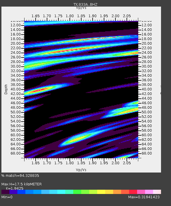
| Estimated Moho Depth: |
17.5 km |
| Estimated Crust Vp/Vs: |
1.94 |
| Assumed Crust Vp: |
6.347 km/s |
| Estimated Crust Vs: |
3.267 km/s |
| Estimated Crust Poisson's Ratio: |
0.32 |
|
| Radial Match: |
94.328835 % |
| Radial Bump: |
243 |
| Transverse Match: |
71.70342 % |
| Transverse Bump: |
400 |
| SOD ConfigId: |
22732711 |
| Insert Time: |
2020-10-20 10:36:58.472 +0000 |
| GWidth: |
2.5 |
| Max Bumps: |
400 |
| Tol: |
0.001 |
|

Signal To Noise
| Channel | StoN | STA | LTA |
| TX:833A: :BHZ:20201006T10:23:05.524999Z | 18.966373 | 1.4312839E-6 | 7.5464285E-8 |
| TX:833A: :BHN:20201006T10:23:05.524999Z | 1.0146492 | 1.8486642E-7 | 1.8219738E-7 |
| TX:833A: :BHE:20201006T10:23:05.524999Z | 19.160395 | 9.776996E-7 | 5.102711E-8 |
| Arrivals |
| Ps | 2.6 SECOND |
| PpPs | 8.0 SECOND |
| PsPs/PpSs | 11 SECOND |


