You are here: Home > Network List > TX - Texas Seismological Network Stations List
> Station PB29 Culberson North > Earthquake Result Viewer
PB29 Culberson North - Earthquake Result Viewer
| Earthquake location: |
Fiji Islands Region |
| Earthquake latitude/longitude: |
-18.0/-178.5 |
| Earthquake time(UTC): |
2020/10/06 (280) 10:11:46 GMT |
| Earthquake Depth: |
629 km |
| Earthquake Magnitude: |
6.0 Mww |
| Earthquake Catalog/Contributor: |
NEIC PDE/us |
|
| Network: |
TX Texas Seismological Network |
| Station: |
PB29 Culberson North |
| Lat/Lon: |
31.75 N/104.51 W |
| Elevation: |
1242 m |
|
| Distance: |
86.4 deg |
| Az: |
55.126 deg |
| Baz: |
246.4 deg |
| Ray Param: |
0.042227983 |
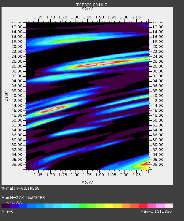
| Estimated Moho Depth: |
27.0 km |
| Estimated Crust Vp/Vs: |
1.88 |
| Assumed Crust Vp: |
6.361 km/s |
| Estimated Crust Vs: |
3.374 km/s |
| Estimated Crust Poisson's Ratio: |
0.30 |
|
| Radial Match: |
80.19208 % |
| Radial Bump: |
400 |
| Transverse Match: |
70.63891 % |
| Transverse Bump: |
400 |
| SOD ConfigId: |
22732711 |
| Insert Time: |
2020-10-20 10:38:07.059 +0000 |
| GWidth: |
2.5 |
| Max Bumps: |
400 |
| Tol: |
0.001 |
|

Signal To Noise
| Channel | StoN | STA | LTA |
| TX:PB29:00:HHZ:20201006T10:22:52.459997Z | 13.472538 | 2.4309538E-6 | 1.8043771E-7 |
| TX:PB29:00:HH1:20201006T10:22:52.459997Z | 4.74846 | 5.591837E-7 | 1.1776107E-7 |
| TX:PB29:00:HH2:20201006T10:22:52.459997Z | 9.942849 | 7.370091E-7 | 7.412454E-8 |
| Arrivals |
| Ps | 3.8 SECOND |
| PpPs | 12 SECOND |
| PsPs/PpSs | 16 SECOND |


