You are here: Home > Network List > G - GEOSCOPE Stations List
> Station MPG Montagne des Peres, French Guyana > Earthquake Result Viewer
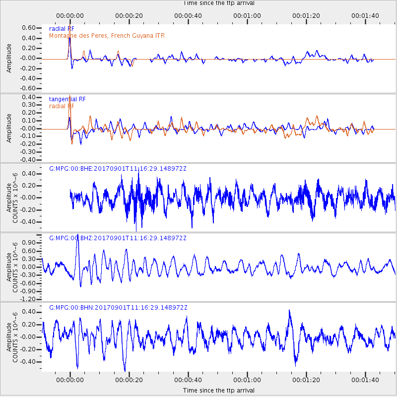
MPG Montagne des Peres, French Guyana - Earthquake Result Viewer
*The percent match for this event was below the threshold and hence no stack was calculated.
| Earthquake location: |
Reykjanes Ridge |
| Earthquake latitude/longitude: |
57.0/-34.0 |
| Earthquake time(UTC): |
2017/09/01 (244) 11:07:37 GMT |
| Earthquake Depth: |
10 km |
| Earthquake Magnitude: |
5.7 Mww |
| Earthquake Catalog/Contributor: |
NEIC PDE/us |
|
| Network: |
G GEOSCOPE |
| Station: |
MPG Montagne des Peres, French Guyana |
| Lat/Lon: |
5.11 N/52.64 W |
| Elevation: |
147 m |
|
| Distance: |
53.8 deg |
| Az: |
203.194 deg |
| Baz: |
12.479 deg |
| Ray Param: |
$rayparam |
*The percent match for this event was below the threshold and hence was not used in the summary stack. |
|
| Radial Match: |
63.58202 % |
| Radial Bump: |
400 |
| Transverse Match: |
59.83102 % |
| Transverse Bump: |
400 |
| SOD ConfigId: |
2307692 |
| Insert Time: |
2017-09-15 11:09:31.859 +0000 |
| GWidth: |
2.5 |
| Max Bumps: |
400 |
| Tol: |
0.001 |
|
Signal To Noise
| Channel | StoN | STA | LTA |
| G:MPG:00:BHZ:20170901T11:16:29.148972Z | 3.3907075 | 5.0714806E-7 | 1.4956998E-7 |
| G:MPG:00:BHN:20170901T11:16:29.148972Z | 1.891966 | 2.1164986E-7 | 1.11867685E-7 |
| G:MPG:00:BHE:20170901T11:16:29.148972Z | 1.1072417 | 1.5911948E-7 | 1.4370798E-7 |
| Arrivals |
| Ps | |
| PpPs | |
| PsPs/PpSs | |


