You are here: Home > Network List > GS - US Geological Survey Networks Stations List
> Station DEC08 Decatur Surface Seismic Site, Decatur, IL, USA > Earthquake Result Viewer
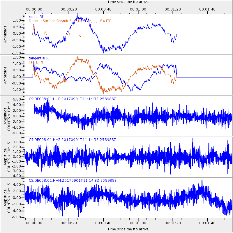
DEC08 Decatur Surface Seismic Site, Decatur, IL, USA - Earthquake Result Viewer
*The percent match for this event was below the threshold and hence no stack was calculated.
| Earthquake location: |
Reykjanes Ridge |
| Earthquake latitude/longitude: |
57.0/-34.0 |
| Earthquake time(UTC): |
2017/09/01 (244) 11:07:37 GMT |
| Earthquake Depth: |
10 km |
| Earthquake Magnitude: |
5.7 Mww |
| Earthquake Catalog/Contributor: |
NEIC PDE/us |
|
| Network: |
GS US Geological Survey Networks |
| Station: |
DEC08 Decatur Surface Seismic Site, Decatur, IL, USA |
| Lat/Lon: |
39.86 N/88.92 W |
| Elevation: |
210 m |
|
| Distance: |
39.1 deg |
| Az: |
268.019 deg |
| Baz: |
45.201 deg |
| Ray Param: |
$rayparam |
*The percent match for this event was below the threshold and hence was not used in the summary stack. |
|
| Radial Match: |
77.72203 % |
| Radial Bump: |
400 |
| Transverse Match: |
35.06767 % |
| Transverse Bump: |
400 |
| SOD ConfigId: |
2307692 |
| Insert Time: |
2017-09-15 11:09:54.936 +0000 |
| GWidth: |
2.5 |
| Max Bumps: |
400 |
| Tol: |
0.001 |
|
Signal To Noise
| Channel | StoN | STA | LTA |
| GS:DEC08:01:HHZ:20170901T11:14:33.258988Z | 1.4113832 | 1.0920372E-6 | 7.7373545E-7 |
| GS:DEC08:01:HHN:20170901T11:14:33.258988Z | 1.5943042 | 2.4283481E-6 | 1.5231398E-6 |
| GS:DEC08:01:HHE:20170901T11:14:33.258988Z | 1.7834955 | 3.015055E-6 | 1.6905312E-6 |
| Arrivals |
| Ps | |
| PpPs | |
| PsPs/PpSs | |


