You are here: Home > Network List > PS - Pacific21 Stations List
> Station PSI Parapat, Indonesia > Earthquake Result Viewer
PSI Parapat, Indonesia - Earthquake Result Viewer
| Earthquake location: |
Eastern New Guinea Reg., P.N.G. |
| Earthquake latitude/longitude: |
-6.1/146.2 |
| Earthquake time(UTC): |
2020/10/08 (282) 07:35:32 GMT |
| Earthquake Depth: |
116 km |
| Earthquake Magnitude: |
6.7 Mi |
| Earthquake Catalog/Contributor: |
NEIC PDE/at |
|
| Network: |
PS Pacific21 |
| Station: |
PSI Parapat, Indonesia |
| Lat/Lon: |
2.69 N/98.92 E |
| Elevation: |
987 m |
|
| Distance: |
48.0 deg |
| Az: |
279.135 deg |
| Baz: |
100.627 deg |
| Ray Param: |
0.069221765 |
| Estimated Moho Depth: |
27.25 km |
| Estimated Crust Vp/Vs: |
1.60 |
| Assumed Crust Vp: |
6.468 km/s |
| Estimated Crust Vs: |
4.036 km/s |
| Estimated Crust Poisson's Ratio: |
0.18 |
|
| Radial Match: |
96.07282 % |
| Radial Bump: |
400 |
| Transverse Match: |
84.8294 % |
| Transverse Bump: |
400 |
| SOD ConfigId: |
22732711 |
| Insert Time: |
2020-10-22 07:46:15.365 +0000 |
| GWidth: |
2.5 |
| Max Bumps: |
400 |
| Tol: |
0.001 |
|
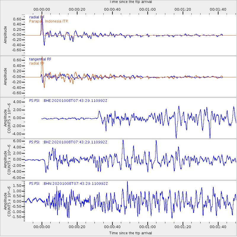
Signal To Noise
| Channel | StoN | STA | LTA |
| PS:PSI: :BHZ:20201008T07:43:29.110992Z | 16.842484 | 1.7951559E-6 | 1.06584984E-7 |
| PS:PSI: :BHN:20201008T07:43:29.110992Z | 1.5392916 | 3.0271738E-7 | 1.966602E-7 |
| PS:PSI: :BHE:20201008T07:43:29.110992Z | 7.7628927 | 8.1513554E-7 | 1.050041E-7 |
| Arrivals |
| Ps | 2.7 SECOND |
| PpPs | 10 SECOND |
| PsPs/PpSs | 13 SECOND |


