You are here: Home > Network List > TA - USArray Transportable Network (new EarthScope stations) Stations List
> Station E20K Nigu River, AK, USA > Earthquake Result Viewer
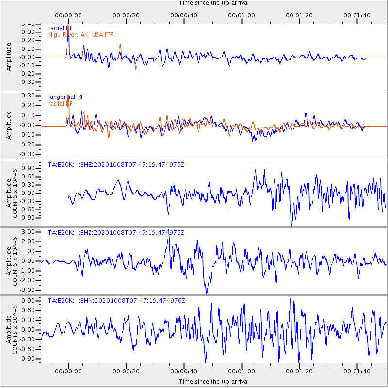
E20K Nigu River, AK, USA - Earthquake Result Viewer
*The percent match for this event was below the threshold and hence no stack was calculated.
| Earthquake location: |
Eastern New Guinea Reg., P.N.G. |
| Earthquake latitude/longitude: |
-6.1/146.2 |
| Earthquake time(UTC): |
2020/10/08 (282) 07:35:32 GMT |
| Earthquake Depth: |
116 km |
| Earthquake Magnitude: |
6.7 Mi |
| Earthquake Catalog/Contributor: |
NEIC PDE/at |
|
| Network: |
TA USArray Transportable Network (new EarthScope stations) |
| Station: |
E20K Nigu River, AK, USA |
| Lat/Lon: |
68.26 N/156.19 W |
| Elevation: |
866 m |
|
| Distance: |
84.2 deg |
| Az: |
18.427 deg |
| Baz: |
237.525 deg |
| Ray Param: |
$rayparam |
*The percent match for this event was below the threshold and hence was not used in the summary stack. |
|
| Radial Match: |
69.17366 % |
| Radial Bump: |
400 |
| Transverse Match: |
64.391106 % |
| Transverse Bump: |
400 |
| SOD ConfigId: |
22732711 |
| Insert Time: |
2020-10-22 07:46:48.015 +0000 |
| GWidth: |
2.5 |
| Max Bumps: |
400 |
| Tol: |
0.001 |
|
Signal To Noise
| Channel | StoN | STA | LTA |
| TA:E20K: :BHZ:20201008T07:47:19.474976Z | 2.429725 | 4.839596E-7 | 1.9918286E-7 |
| TA:E20K: :BHN:20201008T07:47:19.474976Z | 1.2161883 | 2.0544702E-7 | 1.6892697E-7 |
| TA:E20K: :BHE:20201008T07:47:19.474976Z | 1.509058 | 2.7799692E-7 | 1.8421885E-7 |
| Arrivals |
| Ps | |
| PpPs | |
| PsPs/PpSs | |


