You are here: Home > Network List > TA - USArray Transportable Network (new EarthScope stations) Stations List
> Station H31M Peel River, Yukon, CAN > Earthquake Result Viewer
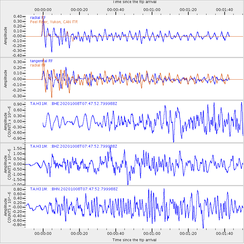
H31M Peel River, Yukon, CAN - Earthquake Result Viewer
*The percent match for this event was below the threshold and hence no stack was calculated.
| Earthquake location: |
Eastern New Guinea Reg., P.N.G. |
| Earthquake latitude/longitude: |
-6.1/146.2 |
| Earthquake time(UTC): |
2020/10/08 (282) 07:35:32 GMT |
| Earthquake Depth: |
116 km |
| Earthquake Magnitude: |
6.7 Mi |
| Earthquake Catalog/Contributor: |
NEIC PDE/at |
|
| Network: |
TA USArray Transportable Network (new EarthScope stations) |
| Station: |
H31M Peel River, Yukon, CAN |
| Lat/Lon: |
65.81 N/134.34 W |
| Elevation: |
642 m |
|
| Distance: |
91.2 deg |
| Az: |
23.905 deg |
| Baz: |
257.878 deg |
| Ray Param: |
$rayparam |
*The percent match for this event was below the threshold and hence was not used in the summary stack. |
|
| Radial Match: |
62.28486 % |
| Radial Bump: |
400 |
| Transverse Match: |
67.24093 % |
| Transverse Bump: |
400 |
| SOD ConfigId: |
22732711 |
| Insert Time: |
2020-10-22 07:47:20.668 +0000 |
| GWidth: |
2.5 |
| Max Bumps: |
400 |
| Tol: |
0.001 |
|
Signal To Noise
| Channel | StoN | STA | LTA |
| TA:H31M: :BHZ:20201008T07:47:52.799988Z | 3.561646 | 3.992621E-7 | 1.12100444E-7 |
| TA:H31M: :BHN:20201008T07:47:52.799988Z | 0.7810569 | 1.3562912E-7 | 1.7364822E-7 |
| TA:H31M: :BHE:20201008T07:47:52.799988Z | 0.7556782 | 1.6785238E-7 | 2.2212151E-7 |
| Arrivals |
| Ps | |
| PpPs | |
| PsPs/PpSs | |


