You are here: Home > Network List > TA - USArray Transportable Network (new EarthScope stations) Stations List
> Station M31M Drury Creek, Yukon, CA > Earthquake Result Viewer
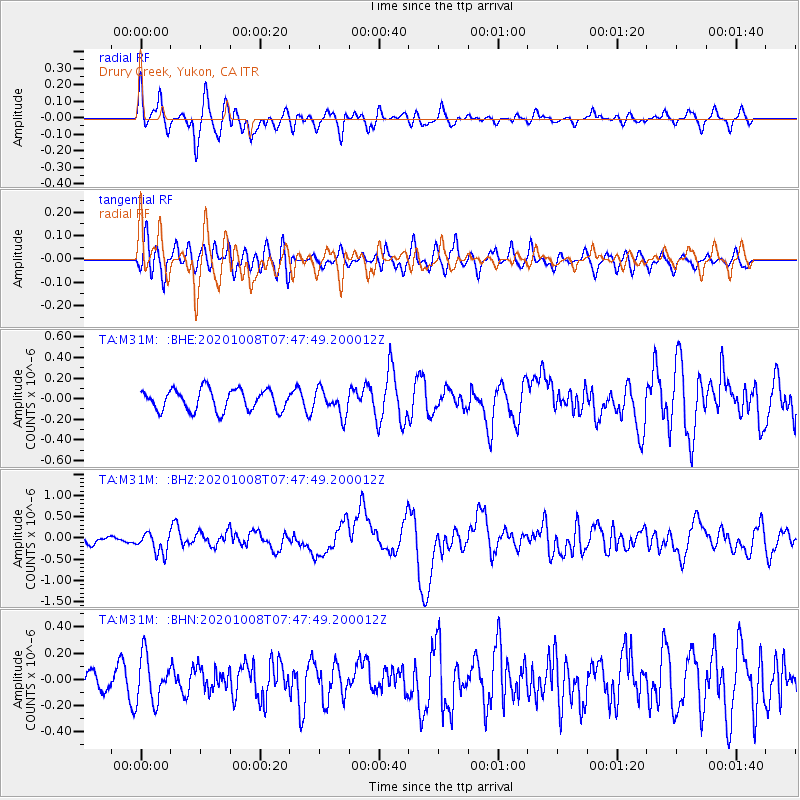
M31M Drury Creek, Yukon, CA - Earthquake Result Viewer
*The percent match for this event was below the threshold and hence no stack was calculated.
| Earthquake location: |
Eastern New Guinea Reg., P.N.G. |
| Earthquake latitude/longitude: |
-6.1/146.2 |
| Earthquake time(UTC): |
2020/10/08 (282) 07:35:32 GMT |
| Earthquake Depth: |
116 km |
| Earthquake Magnitude: |
6.7 Mi |
| Earthquake Catalog/Contributor: |
NEIC PDE/at |
|
| Network: |
TA USArray Transportable Network (new EarthScope stations) |
| Station: |
M31M Drury Creek, Yukon, CA |
| Lat/Lon: |
62.20 N/134.39 W |
| Elevation: |
639 m |
|
| Distance: |
90.4 deg |
| Az: |
27.437 deg |
| Baz: |
257.785 deg |
| Ray Param: |
$rayparam |
*The percent match for this event was below the threshold and hence was not used in the summary stack. |
|
| Radial Match: |
71.8002 % |
| Radial Bump: |
400 |
| Transverse Match: |
49.79747 % |
| Transverse Bump: |
400 |
| SOD ConfigId: |
22732711 |
| Insert Time: |
2020-10-22 07:47:50.183 +0000 |
| GWidth: |
2.5 |
| Max Bumps: |
400 |
| Tol: |
0.001 |
|
Signal To Noise
| Channel | StoN | STA | LTA |
| TA:M31M: :BHZ:20201008T07:47:49.200012Z | 2.5986972 | 2.4317782E-7 | 9.357682E-8 |
| TA:M31M: :BHN:20201008T07:47:49.200012Z | 2.654229 | 1.756232E-7 | 6.616731E-8 |
| TA:M31M: :BHE:20201008T07:47:49.200012Z | 1.1961074 | 1.223119E-7 | 1.02258305E-7 |
| Arrivals |
| Ps | |
| PpPs | |
| PsPs/PpSs | |


