You are here: Home > Network List > TA - USArray Transportable Network (new EarthScope stations) Stations List
> Station O28M Mount Upton, YT, CAN > Earthquake Result Viewer
O28M Mount Upton, YT, CAN - Earthquake Result Viewer
| Earthquake location: |
Eastern New Guinea Reg., P.N.G. |
| Earthquake latitude/longitude: |
-6.1/146.2 |
| Earthquake time(UTC): |
2020/10/08 (282) 07:35:32 GMT |
| Earthquake Depth: |
116 km |
| Earthquake Magnitude: |
6.7 Mi |
| Earthquake Catalog/Contributor: |
NEIC PDE/at |
|
| Network: |
TA USArray Transportable Network (new EarthScope stations) |
| Station: |
O28M Mount Upton, YT, CAN |
| Lat/Lon: |
60.77 N/140.19 W |
| Elevation: |
2622 m |
|
| Distance: |
87.4 deg |
| Az: |
28.115 deg |
| Baz: |
252.708 deg |
| Ray Param: |
0.043127995 |
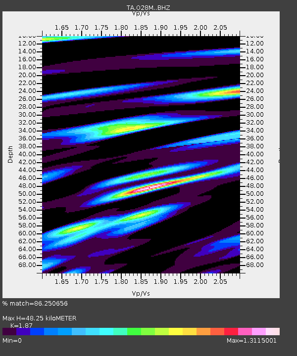
| Estimated Moho Depth: |
48.25 km |
| Estimated Crust Vp/Vs: |
1.87 |
| Assumed Crust Vp: |
6.566 km/s |
| Estimated Crust Vs: |
3.511 km/s |
| Estimated Crust Poisson's Ratio: |
0.30 |
|
| Radial Match: |
86.250656 % |
| Radial Bump: |
400 |
| Transverse Match: |
79.4343 % |
| Transverse Bump: |
400 |
| SOD ConfigId: |
22732711 |
| Insert Time: |
2020-10-22 07:48:03.194 +0000 |
| GWidth: |
2.5 |
| Max Bumps: |
400 |
| Tol: |
0.001 |
|

Signal To Noise
| Channel | StoN | STA | LTA |
| TA:O28M: :BHZ:20201008T07:47:34.875Z | 4.108671 | 4.2719898E-7 | 1.0397497E-7 |
| TA:O28M: :BHN:20201008T07:47:34.875Z | 0.8324609 | 9.741944E-8 | 1.1702585E-7 |
| TA:O28M: :BHE:20201008T07:47:34.875Z | 1.492356 | 1.6694197E-7 | 1.1186471E-7 |
| Arrivals |
| Ps | 6.5 SECOND |
| PpPs | 21 SECOND |
| PsPs/PpSs | 27 SECOND |


