You are here: Home > Network List > TA - USArray Transportable Network (new EarthScope stations) Stations List
> Station TUL3 Leonard, OK, USA > Earthquake Result Viewer
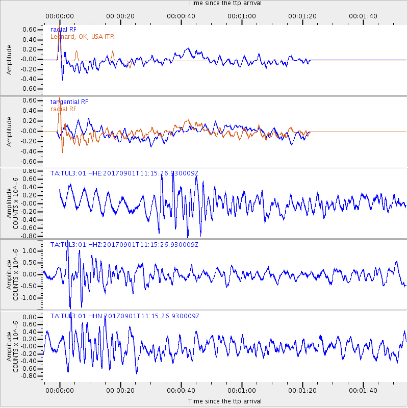
TUL3 Leonard, OK, USA - Earthquake Result Viewer
*The percent match for this event was below the threshold and hence no stack was calculated.
| Earthquake location: |
Reykjanes Ridge |
| Earthquake latitude/longitude: |
57.0/-34.0 |
| Earthquake time(UTC): |
2017/09/01 (244) 11:07:37 GMT |
| Earthquake Depth: |
10 km |
| Earthquake Magnitude: |
5.7 Mww |
| Earthquake Catalog/Contributor: |
NEIC PDE/us |
|
| Network: |
TA USArray Transportable Network (new EarthScope stations) |
| Station: |
TUL3 Leonard, OK, USA |
| Lat/Lon: |
35.91 N/95.79 W |
| Elevation: |
265 m |
|
| Distance: |
45.7 deg |
| Az: |
269.8 deg |
| Baz: |
42.314 deg |
| Ray Param: |
$rayparam |
*The percent match for this event was below the threshold and hence was not used in the summary stack. |
|
| Radial Match: |
66.852615 % |
| Radial Bump: |
400 |
| Transverse Match: |
49.394814 % |
| Transverse Bump: |
400 |
| SOD ConfigId: |
2307692 |
| Insert Time: |
2017-09-15 11:12:34.901 +0000 |
| GWidth: |
2.5 |
| Max Bumps: |
400 |
| Tol: |
0.001 |
|
Signal To Noise
| Channel | StoN | STA | LTA |
| TA:TUL3:01:HHZ:20170901T11:15:26.930009Z | 5.291349 | 6.170009E-7 | 1.16605605E-7 |
| TA:TUL3:01:HHN:20170901T11:15:26.930009Z | 2.2197483 | 3.969099E-7 | 1.7880852E-7 |
| TA:TUL3:01:HHE:20170901T11:15:26.930009Z | 1.9466089 | 3.6904697E-7 | 1.8958455E-7 |
| Arrivals |
| Ps | |
| PpPs | |
| PsPs/PpSs | |


