You are here: Home > Network List > US - United States National Seismic Network Stations List
> Station DUG Dugway, Tooele County, Utah, USA > Earthquake Result Viewer
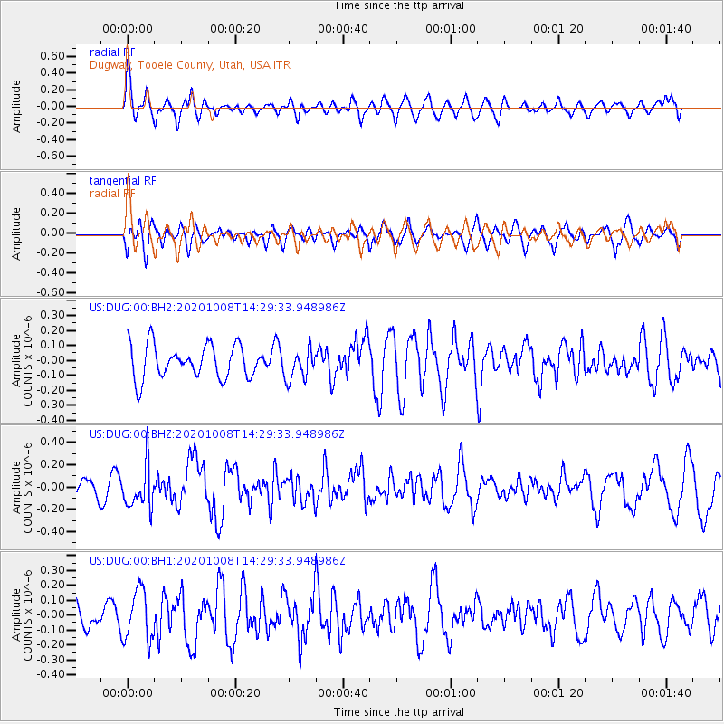
DUG Dugway, Tooele County, Utah, USA - Earthquake Result Viewer
*The percent match for this event was below the threshold and hence no stack was calculated.
| Earthquake location: |
Fox Islands, Aleutian Islands |
| Earthquake latitude/longitude: |
52.7/-168.3 |
| Earthquake time(UTC): |
2020/10/08 (282) 14:22:39 GMT |
| Earthquake Depth: |
37 km |
| Earthquake Magnitude: |
5.7 Mww |
| Earthquake Catalog/Contributor: |
NEIC PDE/us |
|
| Network: |
US United States National Seismic Network |
| Station: |
DUG Dugway, Tooele County, Utah, USA |
| Lat/Lon: |
40.19 N/112.81 W |
| Elevation: |
1477 m |
|
| Distance: |
39.2 deg |
| Az: |
85.811 deg |
| Baz: |
307.624 deg |
| Ray Param: |
$rayparam |
*The percent match for this event was below the threshold and hence was not used in the summary stack. |
|
| Radial Match: |
62.33946 % |
| Radial Bump: |
400 |
| Transverse Match: |
55.985664 % |
| Transverse Bump: |
400 |
| SOD ConfigId: |
22732711 |
| Insert Time: |
2020-10-22 14:39:08.188 +0000 |
| GWidth: |
2.5 |
| Max Bumps: |
400 |
| Tol: |
0.001 |
|
Signal To Noise
| Channel | StoN | STA | LTA |
| US:DUG:00:BHZ:20201008T14:29:33.948986Z | 2.384794 | 1.9286352E-7 | 8.08722E-8 |
| US:DUG:00:BH1:20201008T14:29:33.948986Z | 2.4955022 | 1.6982453E-7 | 6.8052245E-8 |
| US:DUG:00:BH2:20201008T14:29:33.948986Z | 0.9215163 | 1.0157191E-7 | 1.1022259E-7 |
| Arrivals |
| Ps | |
| PpPs | |
| PsPs/PpSs | |


