You are here: Home > Network List > US - United States National Seismic Network Stations List
> Station CBKS Cedar Bluff, Kansas, USA > Earthquake Result Viewer
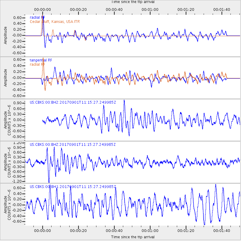
CBKS Cedar Bluff, Kansas, USA - Earthquake Result Viewer
*The percent match for this event was below the threshold and hence no stack was calculated.
| Earthquake location: |
Reykjanes Ridge |
| Earthquake latitude/longitude: |
57.0/-34.0 |
| Earthquake time(UTC): |
2017/09/01 (244) 11:07:37 GMT |
| Earthquake Depth: |
10 km |
| Earthquake Magnitude: |
5.7 Mww |
| Earthquake Catalog/Contributor: |
NEIC PDE/us |
|
| Network: |
US United States National Seismic Network |
| Station: |
CBKS Cedar Bluff, Kansas, USA |
| Lat/Lon: |
38.81 N/99.74 W |
| Elevation: |
677 m |
|
| Distance: |
45.7 deg |
| Az: |
275.776 deg |
| Baz: |
44.106 deg |
| Ray Param: |
$rayparam |
*The percent match for this event was below the threshold and hence was not used in the summary stack. |
|
| Radial Match: |
64.17131 % |
| Radial Bump: |
356 |
| Transverse Match: |
65.01929 % |
| Transverse Bump: |
353 |
| SOD ConfigId: |
2307692 |
| Insert Time: |
2017-09-15 11:12:51.325 +0000 |
| GWidth: |
2.5 |
| Max Bumps: |
400 |
| Tol: |
0.001 |
|
Signal To Noise
| Channel | StoN | STA | LTA |
| US:CBKS:00:BHZ:20170901T11:15:27.249985Z | 2.9038856 | 4.829449E-7 | 1.663099E-7 |
| US:CBKS:00:BH1:20170901T11:15:27.249985Z | 1.4790905 | 3.0515685E-7 | 2.0631386E-7 |
| US:CBKS:00:BH2:20170901T11:15:27.249985Z | 2.016153 | 3.4079346E-7 | 1.6903155E-7 |
| Arrivals |
| Ps | |
| PpPs | |
| PsPs/PpSs | |


